The clock is ticking for groundwater managers in California’s most over-drafted basins
Christina Babbit writes,
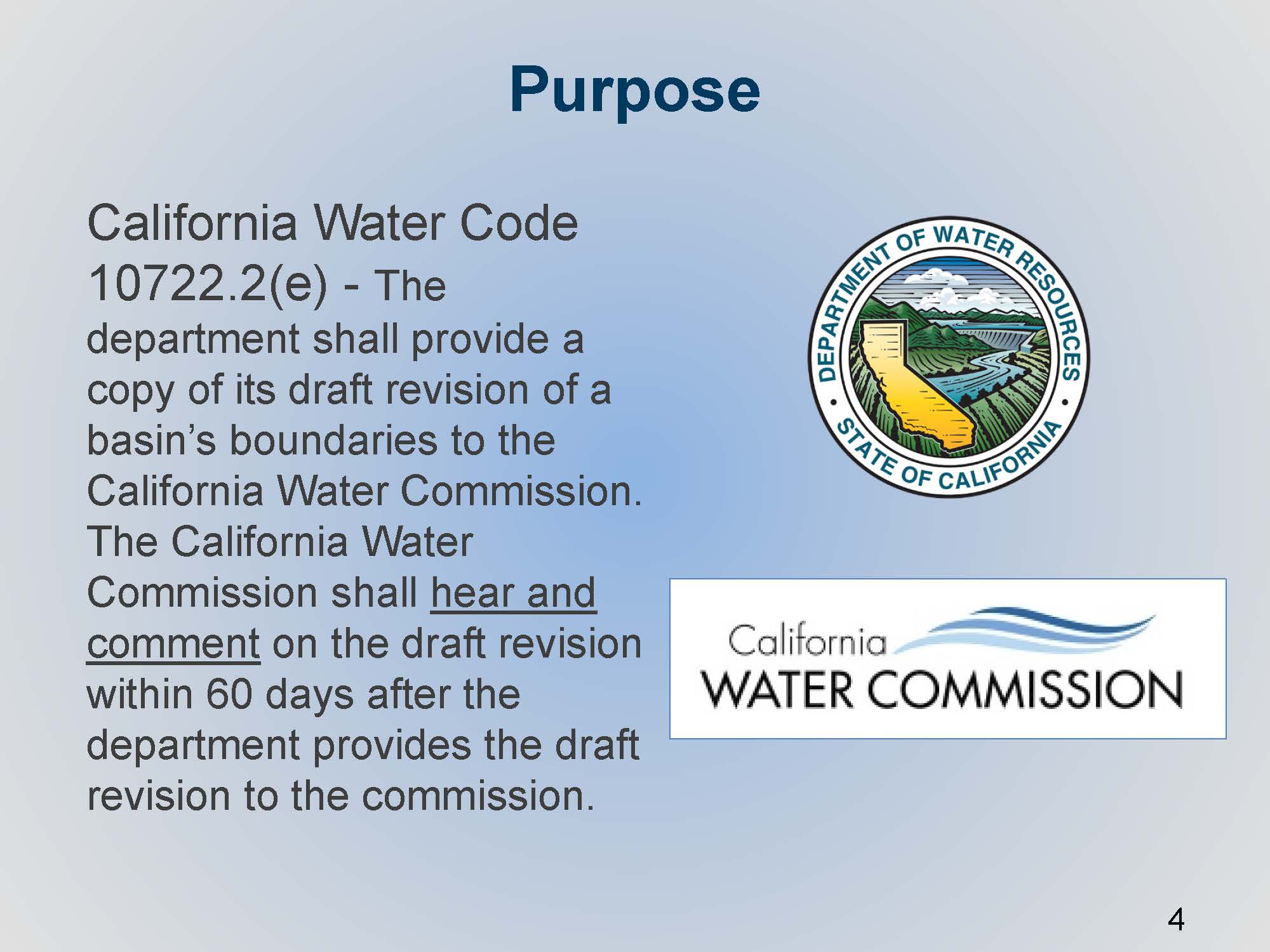
“By this time next year, 21 critically over-drafted groundwater basins in California must submit plans to the state’s Department of Water Resources for how to bring their basins back into balance.
With this major deadline looming, it’s crunch time for water managers and their consultants – some of whom will begin releasing draft plans in the next six to eight months seeking required public comments.
The Jan. 31, 2020, deadline was set by the Sustainable Groundwater Management Act (SGMA), which the California Legislature approved in 2014. … “
Read more from the Growing Returns blog here: The clock is ticking for groundwater managers in California’s most over-drafted basins
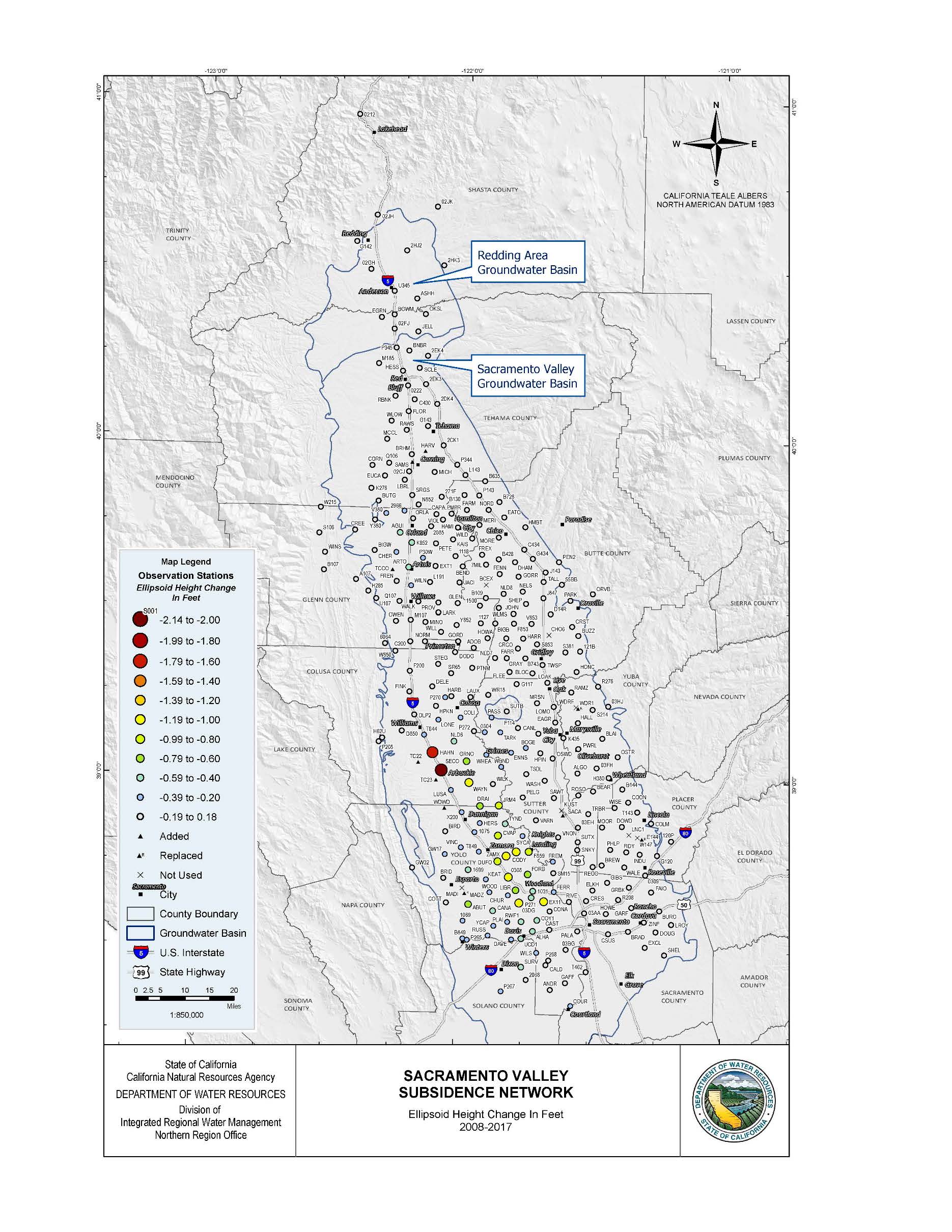
Survey Shows Areas of Land Subsidence in the Sacramento Valley
 Data shows most of the valley has experienced little to no subsidence over the past nine years, with some exceptions
From the Department of Water Resources:
New data released today measure changes in land subsidence in the Sacramento Valley over the past nine years, finding the greatest land surface declines near the city of Arbuckle in Colusa County. According to the Sacramento Valley GPS Subsidence Network Report and accompanying fact sheet, most of the valley has experienced little to no subsidence, however, land in the Arbuckle area has sunk 2.14 feet compared with baseline measurements recorded in the same location in 2008. The report was led by the California Department of Water Resources (DWR), in coordination with 19 state and local agencies.
“We’ve long known that excessive groundwater pumping causes subsidence, which is one of the many reasons we’ve pushed for sustainable groundwater management and pursued innovative tools to better manage and report subsidence throughout the state,” said DWR Director Karla Nemeth. “Data provided by studies like this inform water managers and owners of large infrastructure so they can plan for and prevent against subsidence.”
Land subsidence can damage critical infrastructure, including water delivery systems, levees, roads, and bridges. In 2017, DWR worked with NASA to release a report on San Joaquin Valley subsidence citing areas along the California Aqueduct that have experienced almost two feet of subsidence over three years.
The Sacramento Valley survey results were collected as groundwater levels were recovering from the severe drought of 2012-16, which saw groundwater levels in much of the state reach historic lows. Compared with 2011 pre-drought groundwater levels, the largest decreases were observed in Glenn and Colusa counties at 58 to 43 feet, respectively. Field work indicates that groundwater levels have recovered an average of seven feet, but more frequent and more comprehensive monitoring is needed to more accurately detail the impacts of droughts and high-water years on groundwater levels and subsidence.
The Sacramento Valley GPS Subsidence Monitoring Network, launched by DWR in 2008, surveyed 300 measurement locations in 11 counties from Shasta County in the north to Solano and Sacramento counties in the south. The 2017 resurvey effort was led by DWR’s Division of Integrated Regional Water Management (DIRWM) Northern Region Office (NRO), with the assistance of 19 state, county, and local entities.
“The data provided in this report are an example of the technical assistance we provide and the collaborative effort needed to facilitate successful and sustainable groundwater plans at the local level,” said Taryn Ravazzini, DWR Deputy Director of Special Initiatives.
DWR offers several tools that assist groundwater agencies and the public assess aquifer conditions and plan for sustainable management, including:
- Land Use Viewer: Allows local agencies and the public to access land use survey datasets for the past 30 years.
- Well Completion Report Viewer: Provides information about wells collected during the drilling and construction of water wells.
- SGMA Data Viewer: Compiles many groundwater related datasets that can be used to look at groundwater levels and subsidence.
The Sacramento Valley subsidence report also concludes that areas of Yolo County experienced the most widespread subsidence, in terms of geographic area affected by subsidence, with 31 survey sites measuring a land surface decline between .3 and 1.1 feet. Other statistically significant levels of subsidence were observed at three survey sites in Glenn County (between .44 and .59 feet of subsidence) and five survey sites in Sutter County (between .20 and .36 feet of subsidence).
Sonoma County: Well owners looking at fees for their water usage
From the Santa Rosa Press Democrat:
“Water well owners in Sonoma County may get billed for their annual water usage under a proposed water-conservation plan up for discussion next week at a community meeting in Santa Rosa.
The Santa Rosa Plain Groundwater Sustainability Agency (GSA) is hosting the Jan. 30 meeting to hear feedback on its proposed “groundwater sustainability fee,” which would provide funding to support the new agency. … “
Read more from Sonoma West here: Well owners looking at fees for their water usage
Salinas Valley: A little fee to manage a lot of water
From Voices of Monterey Bay:
“Residents of the Salinas Valley will soon see their utility or water bills go up – but only a little. The new fee, which is likely to be passed by July 1, will add about $2.27 for non-agricultural residents, and $4.81 per irrigated acre for agricultural users. The fee is needed to fund the valley’s newest water agency — the Salinas Valley Basin Groundwater Sustainability Agency.
If the new fee schedule passes, residents in areas managed by the new GSA can expect to likely see the fee included in their property tax bill or their water utility bill by the end of the year. … ”
Read more from Voices of Monterey Bay here: Salinas Valley: A little fee to manage a lot of water
Oxnard prepares for changes in groundwater use
From the Tri County Sentry (Part 1):
“The Oxnard City Council discussed its water future in detail during the Jan. 15 Oxnard City Council meeting as the group learned about how it may allocate groundwater over the next 20 years. The group learned that it needs to make some adjustments and use less water moving forward, which will be a challenge.
Assistant City Attorney Khiri Klima made the presentation and said the Fox Canyon Groundwater Management Agency’s (GMA) groundwater allocation ordinance would significantly affect the city’s groundwater pumping for the next 20 years. … ”
Read more the Tri County Sentry here: Oxnard prepares for changes in groundwater use (Part 1)
Read Part 2 here: Water rates in Oxnard may rise in the future
With the clock running for SGMA, Indian Wells Valley Water District’s workshop plans and prepares
From the Ridgecrest Independent:
“The Groundwater Authority has a little over a year left to create the Groundwater Sustainability Plan, and the Indian Wells Valley Water District is doing everything it can to ensure that happens. The IWV Water District had its first workshop of the year on Wednesday morning, where future plans and goals of the water district were discussed.
The main objective was to ensure that every decision and action that the water district makes is in tune with what the GA is trying to achieve. “I want to make sure that the GSP reflects our inputs,” director Stan Rajtora said. … ”
Read more from the Ridgecrest Independent here: With the clock running for SGMA, Indian Wells Valley Water District’s workshop plans and prepares
Vignettes on Local Groundwater Management in the Sacramento Valley
The NorCal Water Association blog writes,
“Local leaders on the Sacramento Valley floor are well organized and coordinated with respect to groundwater management and the efforts to implement the Sustainable Groundwater Management Act (SGMA). Local Groundwater Sustainability Agencies (GSAs) are all working hard to manage groundwater in a sustainable manner with a focus on completing the initial Groundwater Sustainability Plans (GSPs) by January 2022.
With the emphasis on local agency implementation of SGMA, we have asked many of the local leaders to provide their perspective on local groundwater conditions and the management necessary to manage water resources in a sustainable manner. … “
Continue reading at the Northern California Water Association blog here: Vignettes on Local Groundwater Management in the Sacramento Valley
How Driscoll’s, the world’s largest berry company, is becoming a leader in water conservation
“Even in the depths of winter it’s easy to bite into a plump blackberry or a delicate red raspberry, thanks to Driscoll’s, the world’s largest berry company.
In late 2018, I traveled to the Pajaro Valley, west of Santa Cruz, for a tour of a Driscoll’s research facility, which provided an eye-opening view into how this family-owned company has become an agriculture leader selling berries every month of the year, and why they are so committed to water conservation. … “
Read more from the Growing Returns blog here: How Driscoll’s, the world’s largest berry company, is becoming a leader in water conservation
CALIFORNIA WATER COMMISSION: Groundwater basin boundary modifications
Coverage by Chris “Maven” Austin, excerpted from this post at Maven’s Notebook:
At the January meeting of the California Water Commission, Taryn Ravazzini and Dane Mathis from the Department of Water Resources Sustainable Groundwater Management Program were on hand to brief the commissioners on the draft decisions on the 2018 groundwater basin boundary modifications.
The purpose of the presentation is to hear comment from the commissioners and the public, but it should be noted that in this instance, the Commission does not have an approval role in the Department’s decisions on basin boundaries.
Groundwater basin boundaries are foundational to implementing SGMA because they define the area to managed and modifications to basin boundaries are solely at the request of local agencies.
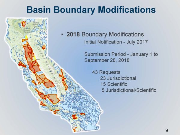
This is the second round of basin boundary modifications that has occurred since the regulations were adopted; the first round was conducted in 2016. The period for applying for modifications began on July 1, 2017 and closed on September 28, 2018.
 Modifying a groundwater basin’s boundaries potentially affects the basin prioritization which is a ranking of the state’s groundwater basin based on eight factors, such as population, the number of water wells, the degree that the overlying population depends on groundwater, irrigated acreage, and others. Those basins with a high and medium priority are subject to SGMA. Basin boundary modifications must be finalized before the prioritization can be finalized.
There are 59 basins whose basin prioritizations could potentially change because they are either requesting basin boundary modifications or would be potentially affected by the results. On January 4, 2019, the Department released the final prioritization for 458 basins who are not impacted by the requested basin modifications. After the basin boundary modifications are finalized, the remaining basin prioritization for the 59 basins will be released; that is expected later this spring.
BASIC DEFINITIONS
A groundwater basin is defined as an aquifer or stacked aquifers with reasonably defined 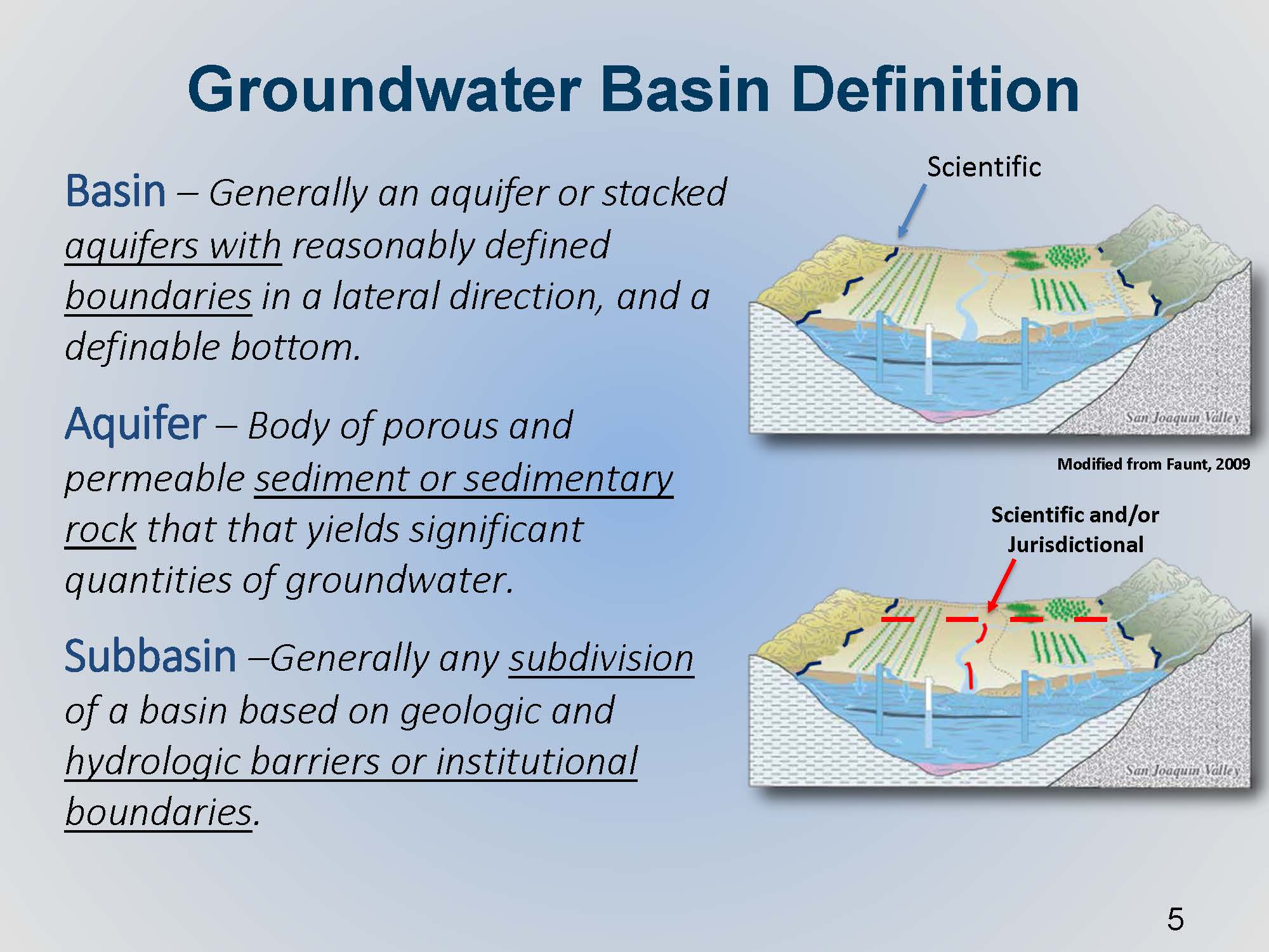 boundaries in a lateral direction and with a definable bottom. An aquifer refers to sedimentary rock or alluvial sediments that can produce a significant economic quantities of groundwater.
The basin’s external boundaries are based upon science and presumably the best available science that we have. However, a basin can be subdivided along lines that reflect jurisdictional or institutional boundaries such as a county line or a water district boundary.
“A basin in itself is not necessarily defined by the land use, whether or not there may or may not be productive wells within the material,” said Mr. Mathis. “It’s not necessarily defined by the presence of a stream channel or perhaps habitat.”
BASIN BOUNDARY MODIFICATION REQUESTS
Basin boundary modification requests can be either scientific or jurisdictional. Scientific revisions are generally to a basin’s external boundaries, although sometimes an internal boundary can be modified based on a hydrogeologic barrier or some other groundwater divide. Jurisdictional modifications are based on other factors, such as moving an internal subbasin boundary from a river to a county line.
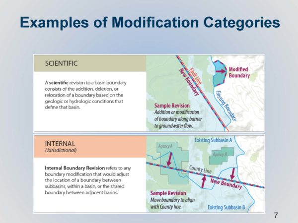
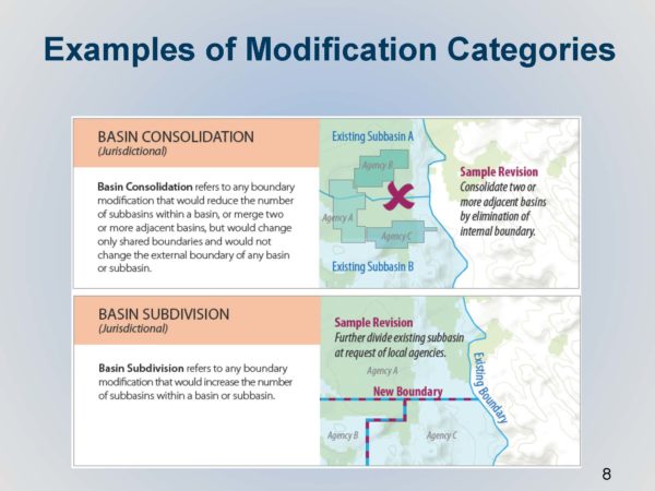
Basins may request that an internal basin boundary gets dissolved or removed, therefore creating a larger basin; alternatively, basins may request to be subdivided into smaller parts.
The Department received 43 individual requests from agencies; 23 of those were jurisdictional, 15 were scientific, and 5 were a combination of both jurisdictional and scientific modifications. The map (below, left) highlights in red and yellow the extent of requests that came into the Department. A wide range of modification requests were received, such as agency requesting an update to only a small segment, or changing a segment from the center of a river line to a county, to requests for basin consolidations.
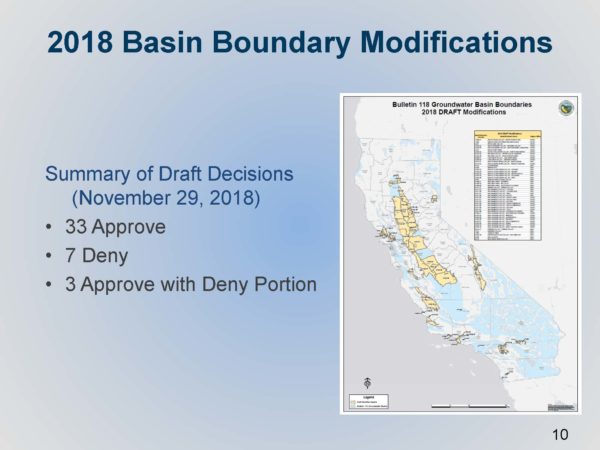
The Department then conducted technical reviews and released their initial draft decisions on November 29. At that time, the Department approved 33 requests, denied 7 requests, and approved 3 with denied portions as there were parts of those requests that didn’t quite meet the regulations.
There were numerous opportunities for public comment; a Groundwater Sustainability Agency’s required notice and consultation activities includes identifying all the stakeholders and interested parties and holding the required meetings. In the case of basin subdivision, agencies have to secure confirmed support from three-quarters of all agencies and all water systems in all of the affected basins that they are wanting to modify, and in some cases, that can be a very high bar to meet, Mr. Mathis said. The general expectation is the agency collects all of that input and hopefully gets the support and comes to the Department without opposition, although that is not necessarily a requirement.
Once the agency submits the modification request to DWR, that opens up a 30-day public comment opportunity to comment on the agency’s request. After DWR released the draft decisions, there was an additional public comment opportunity from November through January 4th. The Department also held a public meeting in December.
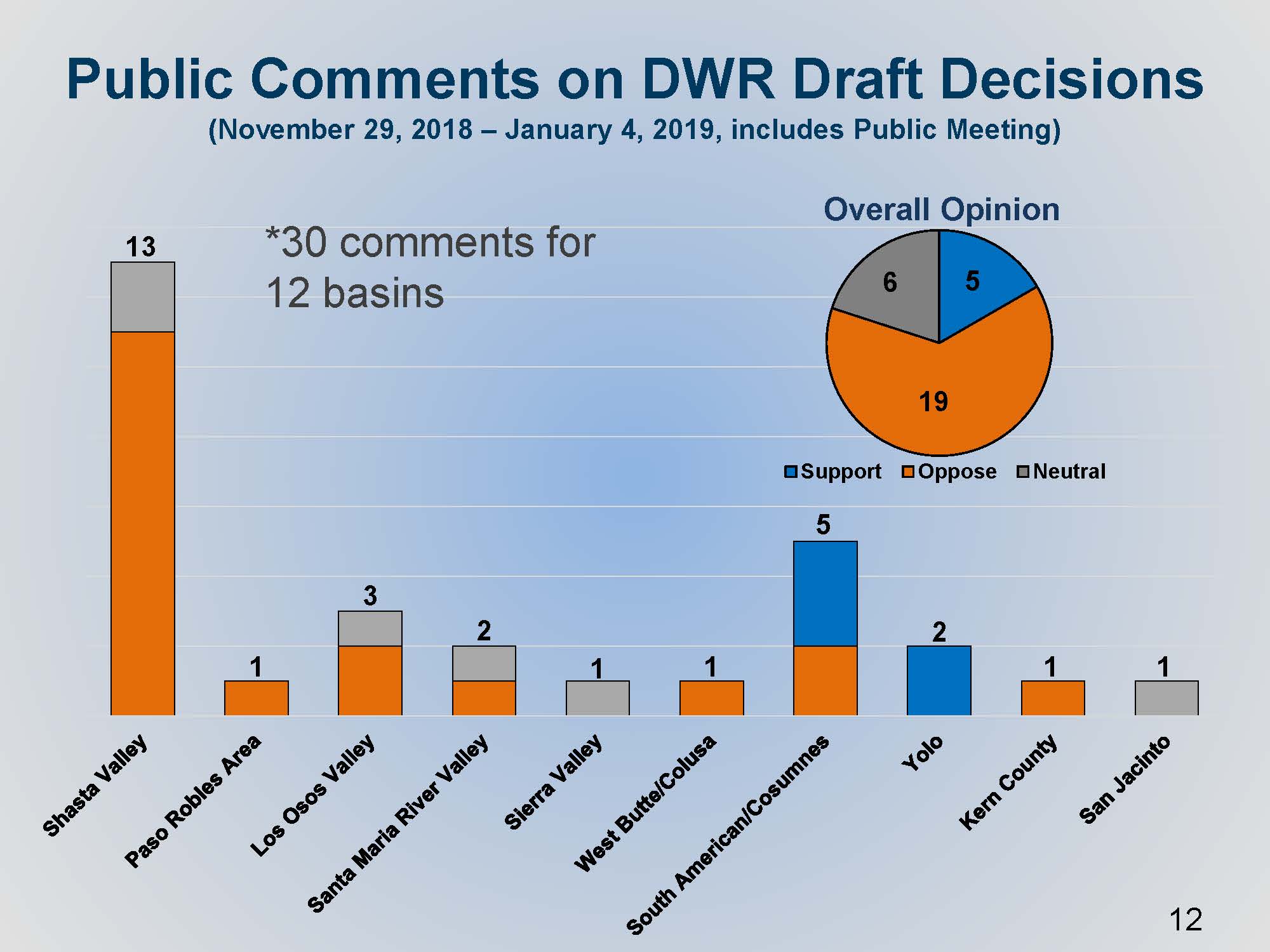 The Department received 30 comments on 12 basins. Mr. Mathis presented a slide showing how the comments were distributed. The Shasta Valley modification request on the left received the most comments, a total of 13. The Shasta Valley modification was denied, and so the comments in orange are reflective of opposition to the Department’s draft decision which is generally reflective of local support, he said. The South American Cosumnes, there was a mix of support and opposition, which was reflective of similar comments received during public comment period.
SOME NOTABLE BASIN BOUNDARY MODIFICATIONS
Mr. Mathis then gave some details on two out of the four modifications that were denied.
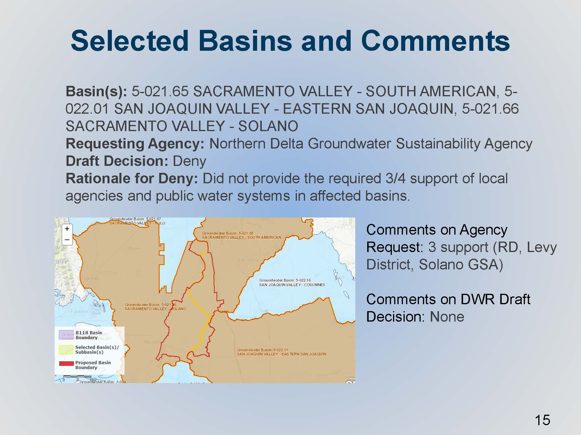 The Northern Delta Groundwater Sustainability Agency submitted a boundary modification request to subdivide three individual basins. On the map, the yellow line represents where the line is today, and the red line and shape is what the agency was requesting. The agency secured support, but the support for the subdivision was only focused on the agencies that were within their new proposed basin, so they did not meet that specific requirement in the regulations to get support from three-quarters of all agencies and all water systems in the affected basins. “As you can imagine, there would be hundreds of them for this particular scenario,” he said.
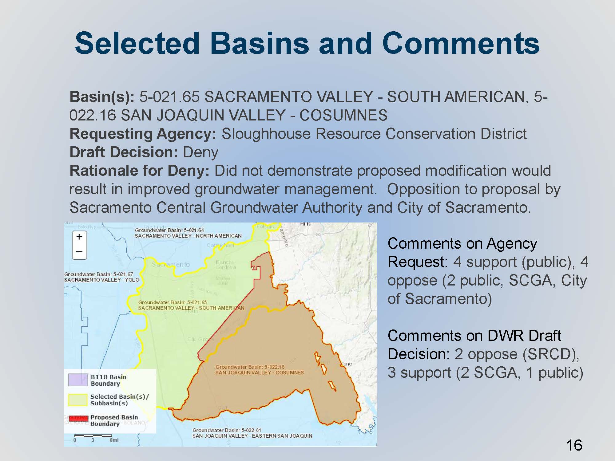 The Sloughhouse Resource Conservation District submitted a request for an internal jurisdictional modification. The yellow line shows the existing internal boundary line; the request request generally involves the expansion of the Consumnes Basin to the north into the southeast part of the South American subbasin. There was some opposition, both from the Sacramento Central Groundwater Authority and the City of Sacramento; the Department’s draft decision to deny also had comment. Sloughhouse RCD was opposing DWR’s decision to deny it, and Sacramento Central Groundwater Authority continued to support DWR’s decision to deny it.
“In general, the main reason we denied it is that it did not appear to support sustainable groundwater management,” said Mr. Mathis. “That’s one of the elements in the regulations that allows the Department as a basis of denial for the request. In summary, there’s local disagreement on what needs to managed and how. The thinking was that it isn’t up to the Department to make that call; it’s really the local agencies that should work together towards meeting the requirements of SGMA. Certainly, they maybe to come back to the Department at a later time when they can show general agreement with each other.”
UPDATED DRAFT DECISIONS
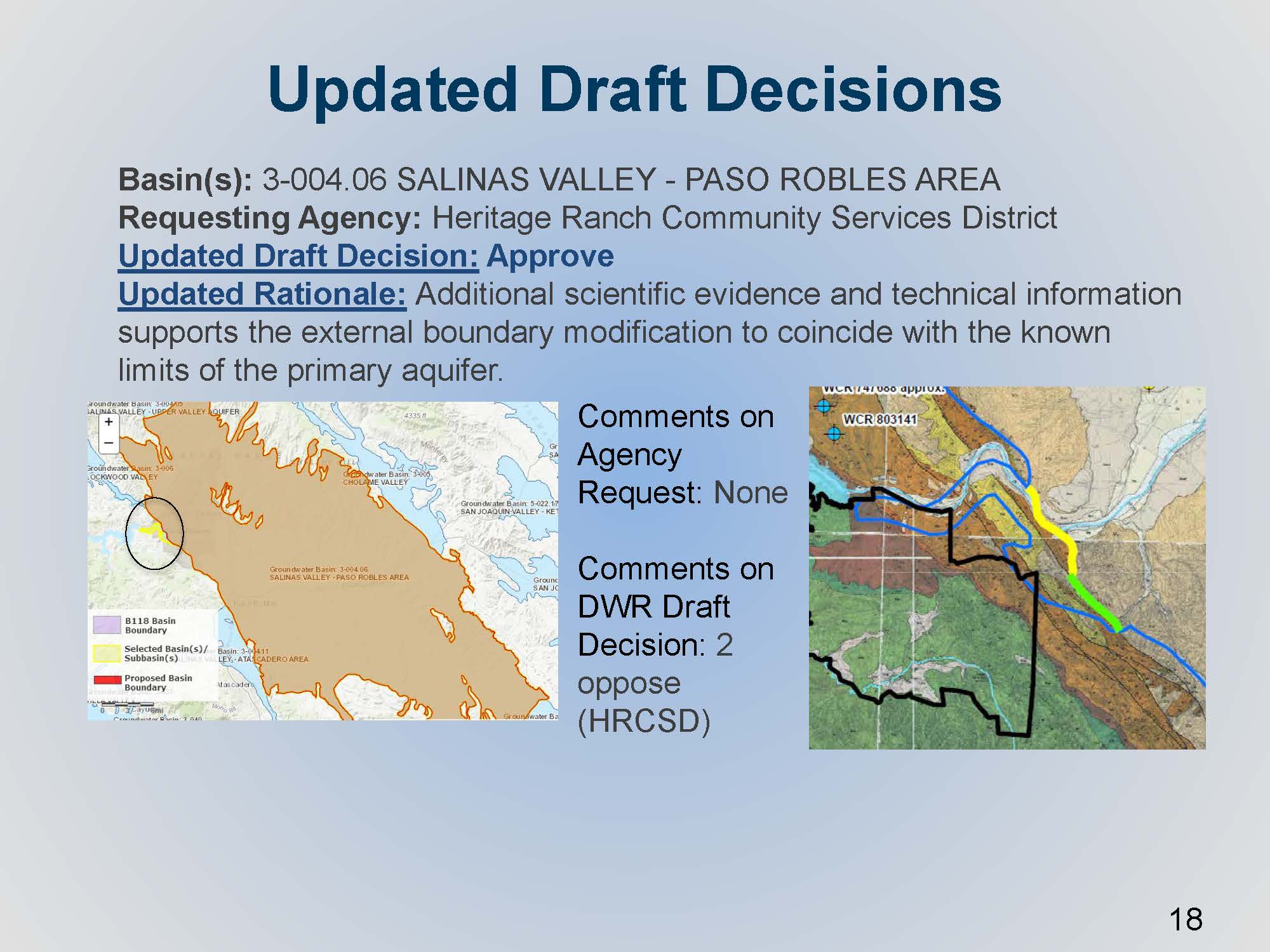 A basin modification request was received from the Heritage Ranch Community Services District regarding a small portion of the Paso Robles area subbasin. On the map on the left, the circle and the yellow line show the small alluvial channel that drains into the main part of the basin. The initial request was denied because the information wasn’t quite clear about the connectivity of that portion to the aquifer that defines the basin; however, the requesting agency subsequently provided supporting information to the Department, so the draft decision was changed to approved.
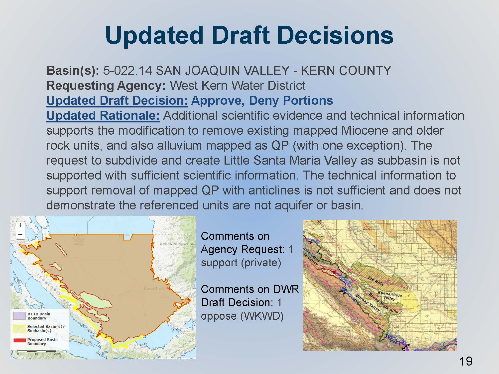 The West Kern Water District submitted a basin boundary modification request for the Kern County subbasin. Most of the requested boundary modification change was an external boundary that would essentially remove or exclude the significant oil producing areas. These areas are somewhat anomalous within a basin; they aren’t quite pieces of bedrock that stick out in the center of the basin, but nonetheless it was based on the different type of land use going on. The Department initially denied the request, because it wasn’t clear about the level of connectivity that these areas potentially had with what’s considered the main aquifer of the basin. The agency submitted their additional technical comments during the period, and the Department did another round of technical review.
“We did another round of reviews on the initial clarifying information,” said Mr. Mathis. “We did change our draft decision a little bit, but not the portion to approve the removal of the anticlines in the oil field areas. The approval was mostly for the perimeter older alluvial units and some older fractured rock units that we know are not indicative of aquifer material, per the regulations.”
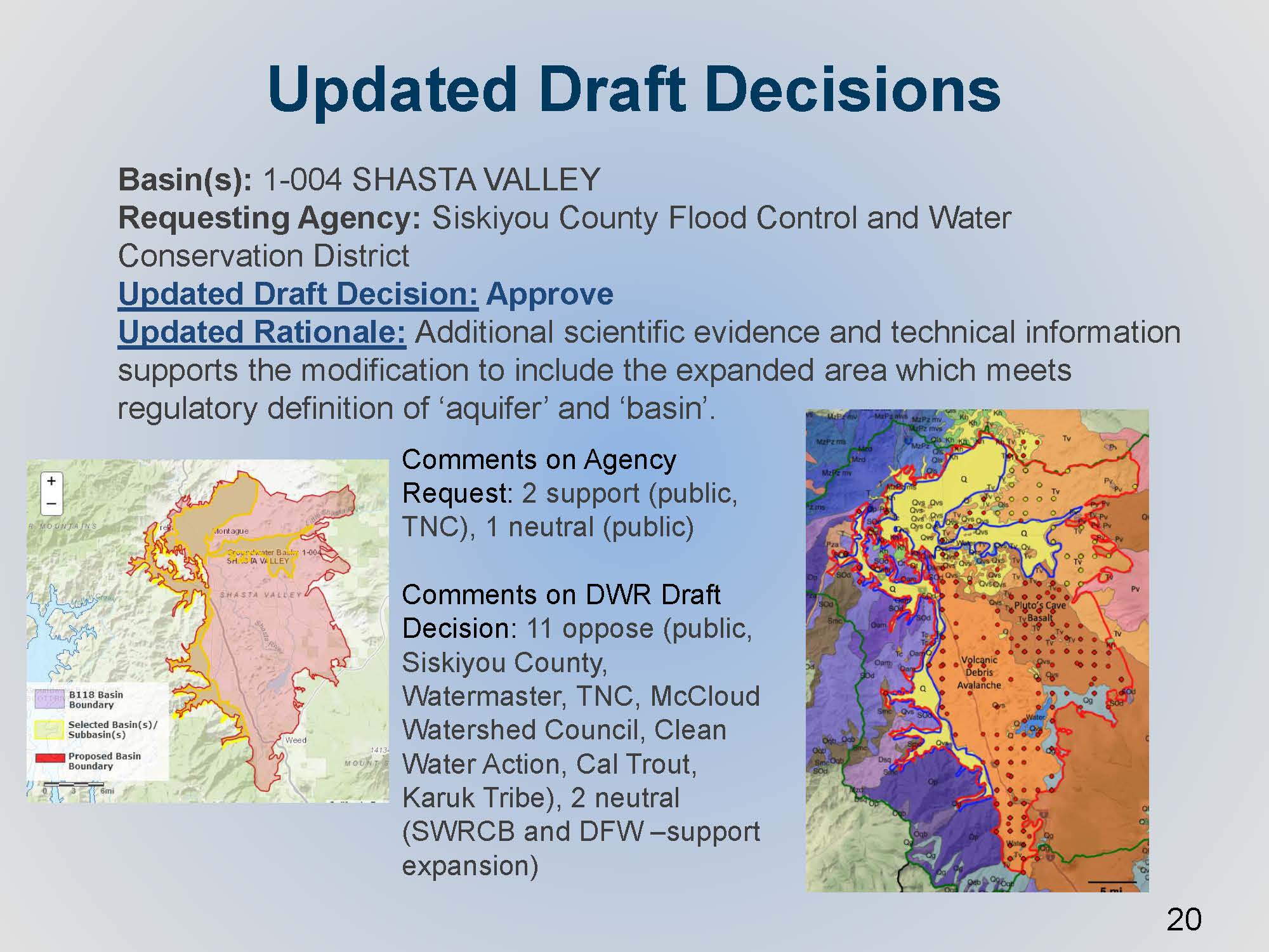 There was a request by Siskiyou County Flood Control and Water Conservation District pertaining to an exposed expansion of the Shasta Valley. The initial request was very thorough with quite a few technical studies to demonstrate their proposed expansion of Shasta Valley, shown in yellow on the graphic; this was a quite a large expansion to the east from the existing basin. They demonstrated a thorough knowledge of the groundwater pumping in the area, the land use, and these volcanic deposits that they had presented. However, the one thing that was missing was the data or the confirmation that the volcanic deposits actually met the definition of aquifer in the regulations, which is defined in the regulation specifically as being reflective of sediments of sedimentary rock that produced economic quantities of groundwater. The agency provided clarifying information to successfully show there was a predominant presence of sediments and sedimentary material, although it’s interspersed within the sequence of volcanic deposits that contribute and make up and define the basin that they are wanting to modify. That updated draft decision is approved by the Department.
IN CONCLUSION
The updated draft decisions were released on last week. Out of 43 requests, 35 were approved, four were denied, and four were approved with only portions denied. The basin boundary modifications are expected to be finalized in February.
FOR MORE INFORMATION …
Departing Nevada state engineer approves controversial water market near Eureka
“In the valley north of the central Nevada town of Eureka, dozens of circle irrigation systems spray water onto alfalfa each spring. The water that flows through the rotating center pivots comes from the ground. But that limited groundwater supply is being overpumped and beginning to dry up at a rate that has long concerned Nevada’s top water regulator, the state engineer.
Each year, water users near Eureka pump more than twice the amount of groundwater from Diamond Valley — a hub for hay growers in central Nevada — than is replenished by Mother Nature. Underneath the valley, the water table has dropped further away from the surface. …
Last week, the state approved a first-of-its-kind plan to reduce water use in Diamond Valley, a community caught between a desire to maintain its agricultural industry and the realities of water availability in the high desert. The plan revolves around the concept of a water market. But it also deviates from Western water law — and will almost certainly be challenged in court.”
Read more from the Nevada Independent here: Departing state engineer approves controversial water market near Eureka