GSA SUMMIT: Setting Sustainable Management Criteria: It’s easy, isn’t it?
 The details of how a groundwater sustainability plan will be implemented are defined by the setting of sustainable management criteria (or SMC). With several undesirable results to consider, a range of technical analyses to perform, data gaps yet to be filled, and potentially conflicting stakeholder interests, the process to establish sustainable management criteria is often involved and challenging.
At the Groundwater Resources Association’s 3rd annual GSA Summit, a panel reviewed how the process went for the groundwater sustainability plans that were submitted to the Department of Water Resources earlier this year, focusing on four of the six sustainable management criteria: water levels, water quality, land subsidence, and interconnected surface waters.
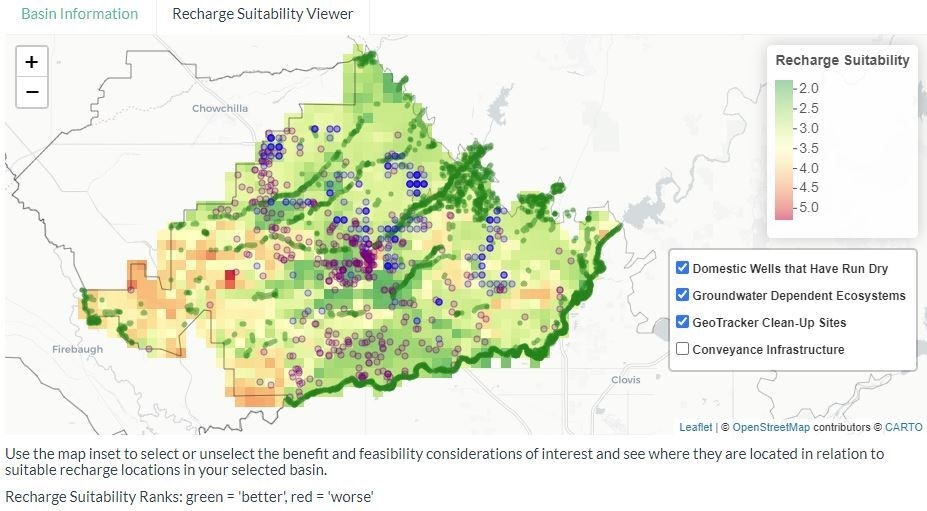
Location, location, location: New tool shows where groundwater recharge will maximize benefits
 From the Environmental Defense Fund:
Recharging groundwater with rain and snowmelt is one strategy water managers are embracing to help balance groundwater supply and demand and comply with the California Sustainable Groundwater Management Act.
Depending on the location, recharge can also deliver other valuable benefits, such as additional habitat for wildlife and a more resilient water supply for people.
With support from EDF, four UC Santa Barbara graduate students have developed a new mapping tool for California’s Central Valley to identify the best locations for groundwater recharge to secure these bonus benefits.
WEBINAR RECORDING: : Tools for Evaluating Drinking Water Needs in SGMA
- Water Foundation’s drinking water analysis of 2020 GSPs
- LCJA’s Human Right to Water GSP Scorecard
- CWC, LCJA, and SHE’s Drinking Water Well Mitigation Framework
Other resources mentioned:
- State Water Boards’ well consolidation website
- American Rivers: Invest in Rivers Storymap
- American Rivers: Economic Outcomes for Urban Floodplain Restoration
- Local Government Commission: Borrego Springs Case Study articles on lessons learned from coordinated water and land-use planning
SGMA in the News
STATEWIDE
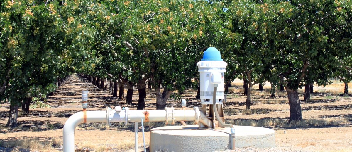
Farmers doing more with less need help from above: “Joel Ackerknecht manages about 3,500 acres of land north and west of Bakersfield and south of Arvin for DM Camp and Sons, a more than 80-year-old Kern County farming operation that grows a variety of specialty crops, including wine grapes, nuts and sweet potatoes. A combination of expanding global demand for California produce, stretched water resources, receding ground water levels and increasing government regulations caused Ackerknecht to search for ways to do more with less. Ackerknecht turned his attention to the sky for help. ... ” Read more the Bakersfield Californian here: Farmers doing more with less need help from above
Sustainable Groundwater Management Act enters crucial period: “As Covid-19 and social unrest dominates news headlines, another problem beneath Central Valley residents’ feet is coming to surface. This was the first year plans had to be submitted for many irrigation districts through the state of California as part of 2014’s Sustainable Groundwater Management Act (SGMA). Sustainability plans developed by groundwater sustainability agencies (GSA) outline how water users can restore depleted water sources. But fights have arisen and disputes about the reliability of those water sources have come to light. … ” Read more from The Business Journal here: Landmark groundwater act enters a crucial period
New study finds media coverage could discourage many from guiding groundwater use: “Superficial media coverage of California’s Sustainable Groundwater Management Act (SGMA) could discourage democratic engagement on resource-management issues by having focused on relatively few stakeholders, a new study from UC Merced shows. Because water is essential to everyone, all have a stake in how groundwater is managed., Media reports published from January 2014 to April 2019 about the SGMA, however, tended to be simplistic, presenting only one stakeholder instead of considering holistic management, the study’s authors said. Media coverage portrayed stakeholders as limited to major economic interests, such as agriculture, the study found. … ” Read more from UC Merced here: New study finds media coverage could discourage many from guiding groundwater use
Report: California groundwater sustainability plans are inadequate: “Though California has allocated billions of dollars in taxpayer-funded bonds to clean up its drinking water and make it more available, one report says it is not working. Even with implementation of the Sustainable Groundwater Management Act (SGMA) under way, upwards of 12,000 drinking wells may go dry by 2040, causing over 120,000 people to lose their primary source of water. The grim report by the Water Foundation, a charitable organization based in California that is focused on clean, reliable water for people and nature, predicts the groundwater sustainability plans written by the various districts in the San Joaquin Valley will not achieve what SGMA purports to do – that is, sustainably manage groundwater resources. … ” Read more from the Western Farm Press here: Report: California groundwater sustainability plans are inadequate
REGIONAL STORIES
Sonoma County workshops provide residents an opportunity to share groundwater concerns: “Sonoma County’s three groundwater sustainability agencies are holding “virtual” community workshops in July. The meetings are an opportunity for well owners, farmers and others in Petaluma Valley, Sonoma Valley and Santa Rosa Plain to learn about groundwater in these basins and to help define local, sustainable groundwater management. … ” Read more from Patch here: Sonoma County workshops provide residents an opportunity to share groundwater concerns
Proposed changes to Paso Robles Groundwater Basin boundaries draw anger and skepticism from landowners: “After seven years of water restrictions over the Paso Robles Groundwater Basin, San Luis Obispo County is redrawing the basin’s boundaries, which will subject hundreds of new property owners to a moratorium on irrigating and other rules. The revised map is part of a package of changes to the county ordinance that regulates the 684-square-mile aquifer in North County. Passed in 2013 amid an ongoing drought, the ordinance was recently extended to 2022 to buy time for the Paso Groundwater Sustainability Plan—which is currently being reviewed by the state—to get implemented. … ” Read more from New Times SLO here: Proposed changes to Paso Robles Groundwater Basin boundaries draw anger and skepticism from landowners
West Valley Water District joins Regional Groundwater Council: “On behalf of the San Bernardino Basin area Groundwater Council, the San Bernardino Valley Municipal Water District (SBVMWD) announced that the West Valley Water District (WVWD) will join the basin area council. The San Bernardino Valley has experienced historically low rainfall over the past 20 years, resulting in ongoing and sustained drought. This has resulted in groundwater storage levels in the San Bernardino Basin being at a historic low. Due to our tendency to long periods of drought, ensuring water supply reliability and long-term groundwater sustainability is even more important in this region. ... ” Read more from the Community News here: West Valley Water District joins Regional Groundwater Council
Ventura County: Completed project for groundwater recharge captures stormwater: “According to the state, this year is the 11th driest snowpack on record since 1950 and with the State Water Project announcing it will deliver only 20% of requested water supplies in 2020, projects like the Piru Stormwater Capture for Groundwater Recharge Project are critical to Ventura County’s important water supplies. This project will provide a sustainable source for recharge of the Piru Groundwater Basin and improve water quality in Piru Creek. ... ” Read more from The Patch here: Completed project for groundwater recharge captures stormwater
GSA SUMMIT: Lessons learned from the 2020 GSPs: Perspectives from the critically overdrafted basins
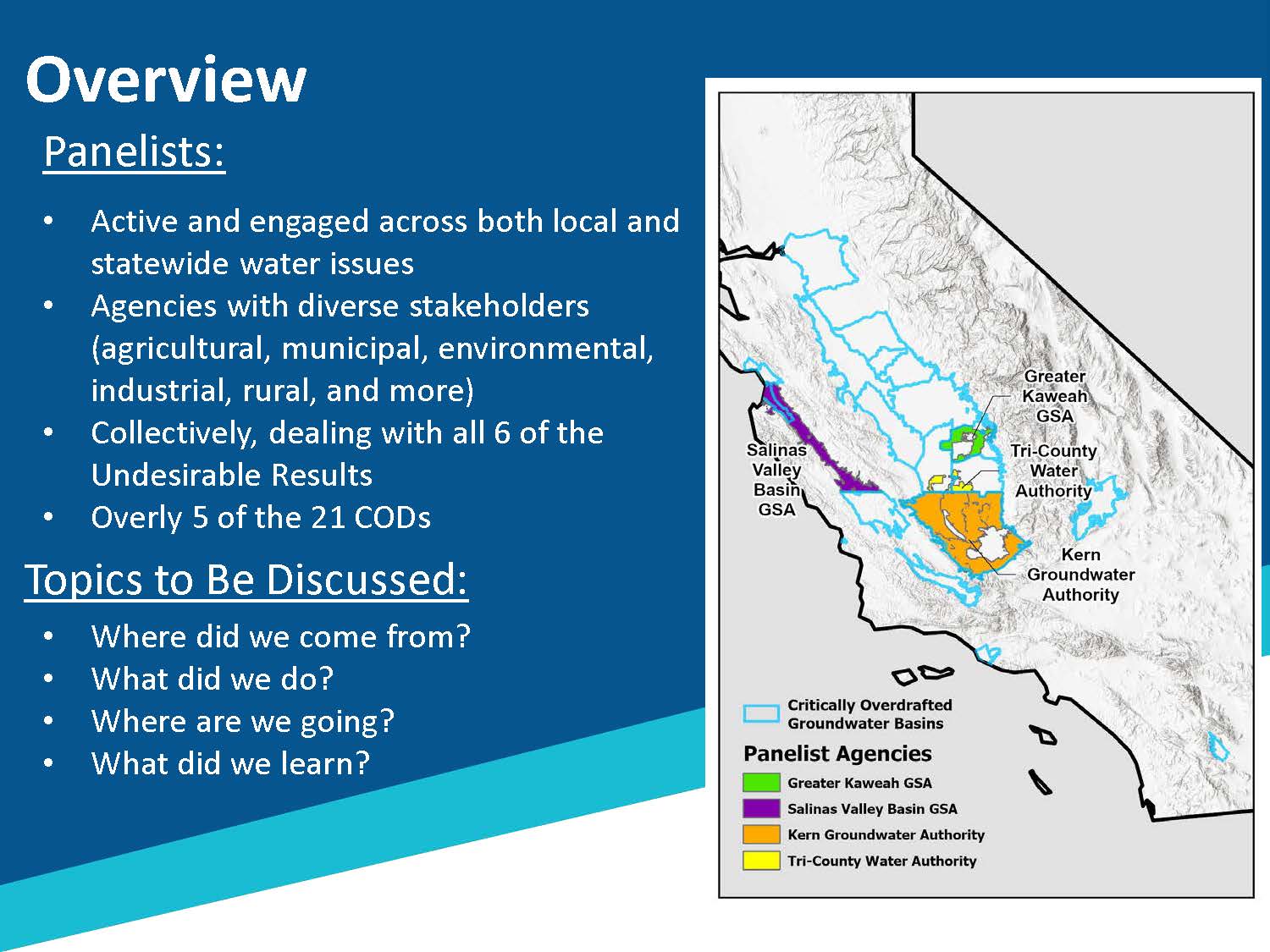 The implementation phase of the Sustainable Groundwater Management Act has now begun for the basins designated as critically-overdrafted. Getting to this point has been an unparalleled journey as communities, farmers, water suppliers, and others navigated through uncharted territory to develop local solutions for sustainable groundwater management. At the Groundwater Resources Association Third Annual Groundwater Sustainability Agency Summit held online in June, a panel of managers from four of the critically overdrafted basins reflected on the hard work of developing and adopting a groundwater sustainability plan.
Seated on the panel were Gary Petersen from the Salinas Valley Basin GSA; Eric Osterling from the Mid Kaweah GSA; Deanna Jackson from TriCounty GSA; and Patricia Poire from the Kern Groundwater Authority. Collectively, these GSAs are having to deal with all six of the undesirable results, from subsidence to groundwater levels to seawater intrusion, and they overly five of the 21 critically overdrafted basins.
Each panelist then discussed the process that they went through in developing their plans, the lessons they learned, and their advice for those developing the plans that will be due in January of 2022.
Click here to read this article.
GSA SUMMIT: Reflections on the 2020 GSP process
 At the end of January of this year, the state’s critically overdrafted groundwater basins submitted their adopted groundwater sustainability plans (or GSPs), meeting an important deadline in the Sustainable Groundwater Management Act; the remaining basins subject to SGMA will be submitting their plans in January of 2022. The Department of Water Resources will now have two years to review the plans to determine their adequacy.
At the Third Annual GSA Summit, Craig Altare, chief of the Groundwater Sustainability Plan section at the Department of Water Resources’ Sustainable Groundwater Management Office or SGMO, reflected on the GSPs and how the implementation of SGMA is playing out.
Click here to read this article at Maven’s Notebook.
UPDATED TOOL: New features added to Water Tracker, a tool that displays the distribution of surface water across the Central Valley
From Point Blue Conservation Service:
With summer in full swing, it may be time to begin evaluating plans for the coming fall and winter seasons. If you are interested in learning more about the distribution of surface water across the Central Valley both in the past and in near real-time, we invite you to explore some exciting new features at Water Tracker – www.pointblue.org/watertracker
![]() Explore wetland vegetation. Recent work by USGS provides annual maps of wetland vegetation across the Central Valley.
Explore wetland vegetation. Recent work by USGS provides annual maps of wetland vegetation across the Central Valley.
Two layers are available:
Wetland vegetation type, aka moist soil seed plants (swamp timothy, watergrass, cocklebur, etc.)
Habitat structure (tall emergent, open water, bare ground, etc.)
These data (2007-2017) are now available for viewing and downloading from the Map Viewer in Water Tracker. Learn more about from a recent publication led by Kristin Byrd at USGS.
Summaries of water from custom areas. You can now upload a shapefile or draw a custom spatial area and then, both download the data, AND get a summary of water in that area over time with interactive time-series plots. See an example here.
Coming soon. In the next several months we plan to make more data layers available including fallow fields (2000-2017), bird distribution/suitability (4 shorebirds, 4 waterfowl), giant garter snake distribution/suitability, groundwater recharge (based on Basin Characterization Model) and more!
What do managers need?
At the Central Valley Wetland Managers meeting in March, we shared spatial data we are currently developing, including fallow fields, wetland vegetation and types, groundwater recharge potential, bird and snake distribution/suitability maps, as well as some of the forecasting tools (within-year and long-term) in development.
A survey of participants in the meeting resulted in helpful feedback:
(1) most wetland managers’ first priority is their wetland complex
(2) for data to be most helpful for decision-making it should be made available in February/March and July/August, and
(3) visualizations and semi-custom summaries and/or reports appear to be the most appealing at this point.
We want these data and technologies to be useful and help wetland managers do their jobs, so we will be working to make sure that Water Tracker can deliver on these needs for wetland managers. Any feedback from the community is welcome. Email us at watertracker@pointblue.org to let us know what you need.
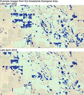 How is 2020 looking so far?
Overall, based on data from Water Tracker, the first 5 months of 2020 had, on average, 10% lower open water than the 2013-2019 average for these months. Only April had more open on the landscape water than the previous 7-year average and February had the lowest with a 17% reduction from average conditions. This is not surprising given the dry spell this winter. The estimated extent of open water in seasonal wetlands was also lower (-5%) across the first 5 months of 2020 compared to the recent 7-year average.
What is Water Tracker?
As a reminder, Water Tracker uses Landsat satellite imagery to update the distribution of open surface water in the Central Valley. It’s refreshed every 16 days. Water Tracker displays where open surface water is in the Central Valley in map form and also provides data summaries.
Anyone can quickly and easily get a picture of where the water is and isn’t, now and in the recent past. Data are available starting in 2013 (as far back as 2000 can be requested). Data can also be downloaded directly from Water Tracker.
There are a multitude of ways these data can inform decisions. Recent examples include 1) using the tool to decide on the best places to add water for the millions of waterbirds that rely on the Central Valley, and 2) to better understand the impacts of extreme drought on waterbird habitat availability.
Tell us how you are using Water Tracker
Please share your stories with us about how you are using Water Tracker at watertracker@pointblue.org. The best way for us to support this free, open-source resource is through understanding and highlighting how it is most useful.
Thank you for using and sharing Water Tracker in an effort to work towards meeting the water needs of both wildlife and people.
Click here for the Water Tracker Tool.
WATER WRIGHTS: San Luis-Delta Mendota WA, Semitropic WSD, Kern Water Bank, Friant WA, Westlands, and more …
![]() A recap of what’s recently been posted at Water Wrights, a website that covers Central Valley water meetings:
A recap of what’s recently been posted at Water Wrights, a website that covers Central Valley water meetings:
- San Luis Delta Mendota Water Authority July 9, 2020
- Semitropic Water Storage District July 8, 2020
- Kern Water Bank July 7, 2020
- Kaweah Delta Water Conservation District July 7, 2020
- Dairy’s Shrinking Water Footprint: A Key Piece of the SGMA Puzzle July 6, 2020
- Friant Water Authority June 25, 2020
- Glenn Colusa Irrigation District June 18, 2020
- Yuba Water Agency June 16, 2020
- Western Canal Water District, June 16, 2020
- Madera Irrigation District Board, Board of Equalization & GSA Meeting June 16, 2020
- Westlands Water District June 16, 2020
- Friant Water Authority Ex Cmt June 15, 2020
Click here to read all articles at WaterWrights.net.
SGMA in the News
Farmland values hinge on future water availability: “Availability of water and the impact of the Sustainable Groundwater Management Act continue to be a main focus when California agricultural appraisers determine land values, particularly in water-short regions. During a business conference held virtually last week, the California Chapter of the American Society of Farm Managers and Rural Appraisers also touched on other issues affecting land values, including supply-and-demand dynamics for various crops and market conditions, especially under COVID-19. … ” Read more from Ag Alert here: Farmland values hinge on future water availability
Dairy’s shrinking water footprint: a key piece of the SGMA puzzle: “The implementation of the Sustainable Groundwater Management Act (SGMA) and other anticipated water restrictions pose major challenges for California agriculture. Without effective solutions, economists have estimated that up to one million acres of farmland will be fallowed, resulting in a revenue loss of $7.2 billion per year. As the state’s top agricultural commodity, dairy farming is an important part of the SGMA challenge. Fortunately, dairy farmers have an excellent track record for water savings and are continuing to adopt innovative strategies to advance environmental sustainability and help meet the water conservation challenges ahead. … ” Read more from Water Wrights here: Dairy’s shrinking water footprint: a key piece of the SGMA puzzle
Sacramento region plans to store water underground as a climate change adaptation strategy: “The Sacramento region is preparing for the long term impacts of the climate crisis when it comes to water supply. Central to the plan is a groundwater storage program with two to three times the space of Folsom Lake. As the climate warms it’ll likely become harder to fill up reservoirs, because the snowpack could be small for multiple years. Think of the nearly empty reservoirs across California during the most recent drought. “We’re expecting in the future to have more severe droughts and potential for Folsom Reservoir to not fill up with the frequency that it does,” said James Peifer, executive director of the Regional Water Authority. ... ” Read more from Capital Public Radio here: Sacramento region plans to store water underground as a climate change adaptation strategy
Proposed changes to Paso Robles Groundwater Basin boundaries draw anger and skepticism from landowners: “After seven years of water restrictions over the Paso Robles Groundwater Basin, San Luis Obispo County is redrawing the basin’s boundaries, which will subject hundreds of new property owners to a moratorium on irrigating and other rules. The revised map is part of a package of changes to the county ordinance that regulates the 684-square-mile aquifer in North County. Passed in 2013 amid an ongoing drought, the ordinance was recently extended to 2022 to buy time for the Paso Groundwater Sustainability Plan—which is currently being reviewed by the state—to get implemented. … ” Read more from New Times SLO here: Proposed changes to Paso Robles Groundwater Basin boundaries draw anger and skepticism from landowners
Fillmore: Groundwater recharge capturing project completed: “According to the state, this year is the 11th driest snowpack on record since 1950 and with the State Water Project announcing it will deliver only 20% of requested water supplies in 2020, projects like the Piru Stormwater Capture for Groundwater Recharge Project are critical to Ventura County’s important water supplies. This project will provide a sustainable source for recharge of the Piru Groundwater Basin and improve water quality in Piru Creek. … ” Read more from the Fillmore Gazette here: Groundwater recharge capturing project completed
GROUNDWATER 101: The basics
 Dr. Thomas Harter provides a basic understanding of groundwater – what it is, how much groundwater is out there, how fast groundwater moves, and where it comes from and where it goes
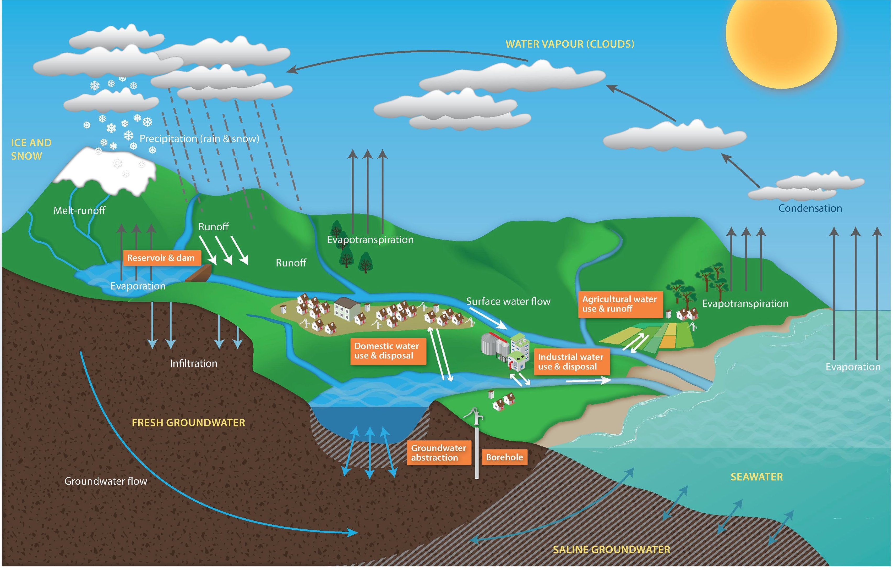
Groundwater is an important part of California’s – and the nation’s water supply. Nationwide, groundwater makes up on average 26% of the water supply. In California, that number is significantly higher – groundwater provides nearly 40% of the water used by California’s farms and cities, and significantly more in dry years. But what is groundwater? In this post based on the first segment of the UC Davis shortcourse on groundwater, Dr. Thomas Harter, who is the Robert M. Hagan Endowed Chair for Water Resources Management and Policy at the University of California, Davis as well as Professor and Cooperative Extension Specialist in the Department of Land, Air, and Water Resources (among many other things), provides a basic understanding of groundwater – what it is, how much groundwater is out there, how fast groundwater moves, and where it comes from and where it goes.