As climate change increases the number of extreme weather events, such as megadroughts, groundwater management is key for sustaining water supply. But current groundwater monitoring tools are either costly or insufficient for deeper aquifers, limiting our ability to monitor and practice sustainable management in populated areas.
Now, a new paper published in Nature Communications bridges seismology and hydrology with a pilot application that uses seismometers as a cost-effective way to monitor and map groundwater fluctuations.
“Our measurements are independent from and complementary to traditional observations,” says Shujuan Mao PhD ’21, lead author on the paper. “It provides a new way to dictate groundwater management and evaluate the impact of human activity on shaping underground hydrologic systems.”
A new web-based tool developed by the Department of Water Resources (DWR) will allow the public to explore thousands of groundwater projects across California to get a better understanding of one of the state’s most critical water supply resources. The virtual mapping tool is part of the State’s ongoing commitment to develop new, innovative solutions to provide information and resources to address the effects of California’s changing climate and ongoing severe drought.
The California Groundwater Projects Tool is an interactive mapping tool that allows users to explore a database of nearly 3,000 projects initiated in California over the last decade to protect groundwater resources. The mapping tool features projects that were funded by DWR and external sources such as federal or local funding. The database will include information about project benefits and effectiveness in relation to the Sustainable Groundwater Management Act (SGMA). Users can also access more than 20 project case studies and get guidance on how to measure and track benefits of projects following construction.
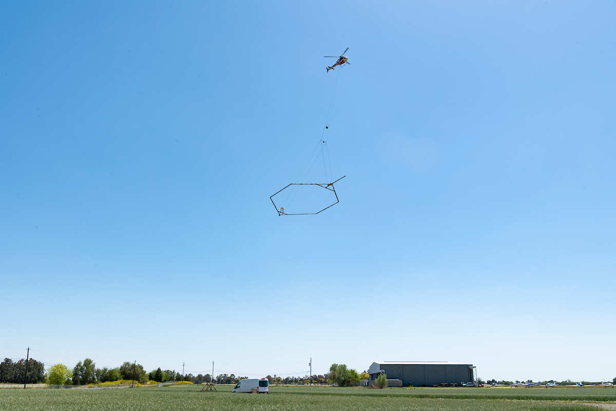
A helicopter demonstrates how this AEM subterranean survey is conducted to find where water is more likely to exist.. Photo by Andrew Innerarity/ DWR
From the Department of Water Resources:
With California in the third year of a severe drought and facing continued extreme weather swings, the California Department of Water Resources (DWR) has been developing and using new data and forecasting tools to better anticipate and manage available water supplies.
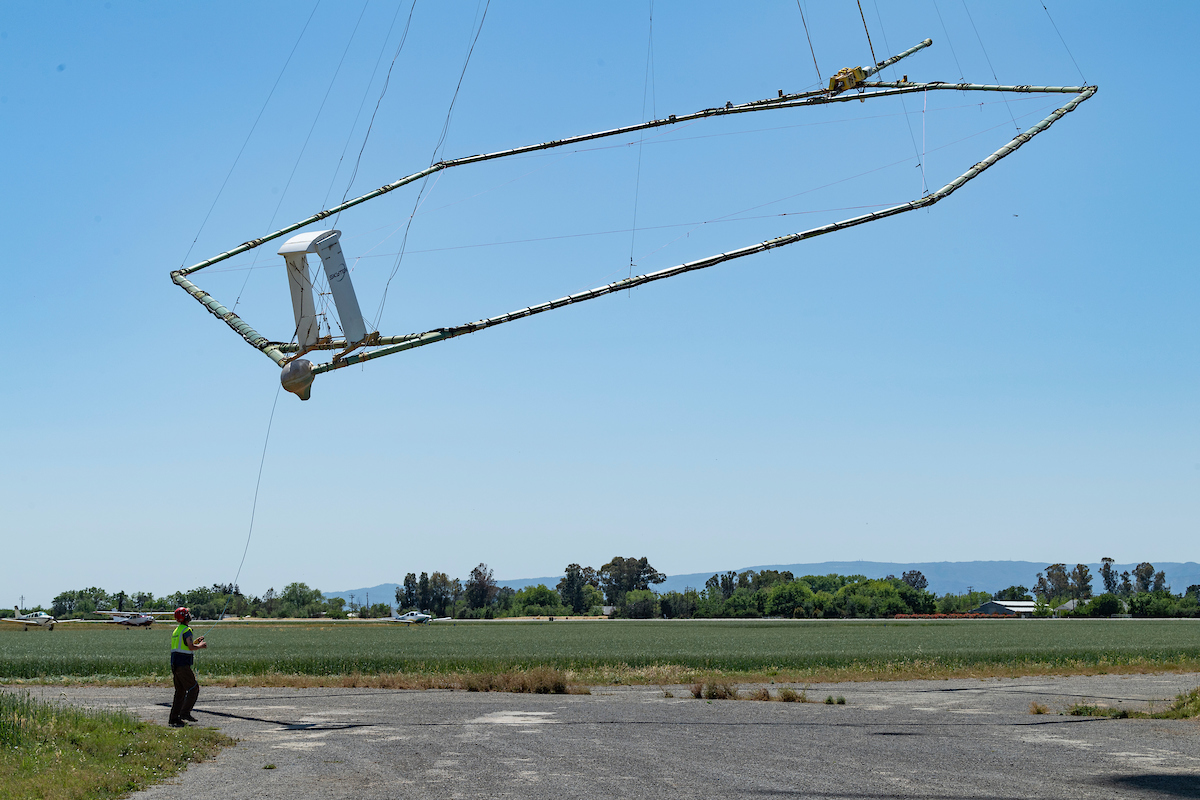
One new technology that DWR is implementing statewide is collecting airborne electromagnetic (AEM) data across California to better understand the groundwater aquifer structure and to support the state and local goal of sustainable groundwater management. The AEM method is an innovative helicopter-based technology that has been compared to taking an MRI of the subsurface, which helps DWR to better understand underground geology. The resulting underground images provide local groundwater sustainability agencies (GSAs) with data to identify priority areas for recharging groundwater.
With California facing a severe drought and an increased reliance on the State’s groundwater basins, today the Department of Water Resources (DWR) released the final version of California’s Groundwater – Update 2020. The report, also known as Bulletin 118, contains critical information about the condition and use of the state’s groundwater, which is especially important as California faces the real-time impacts of climate change and drought.
“Groundwater plays a central role in sustaining our state’s ecosystems, businesses, agriculture, and people, with some Californians relying solely on groundwater for drinking water,” said DWR Director Karla Nemeth. “The updated California’s Groundwater provides key information for the state and locals to better understand and manage groundwater as we adapt to variations in climate and navigate a historic drought.”
Openet is a satellite-based data resource supplying crucial water use information in 17 Western U.s. States.
Using the best available science to provide easily accessible satellite-based estimates of water use, OpenET is being used to improve U.S. water management. The data is available on 17 western states, most notably the area covered by the Colorado River basin.
The “ET” in OpenET stands for evapotranspiration, which is the process through which water leaves plants, soils, and other surfaces and returns to the atmosphere. It’s a measurement that farmers can use to estimate the amount of water being taken up or used by their fields and crops and that will usually need to be replaced through irrigation or rainfall.
“The water spigots on California farms will soon be twisted tighter.
As the state faces a growing threat from drought, an increasing number of water agencies are planning to require flow meters on agricultural wells, part of a landmark effort to measure and constrain pumping that used to be free and unlimited. It’s a controversial step aimed at protecting water supplies that could change cultivation practices in the Golden State’s thirsty fields.
“It’s hard to be as efficient as possible if you don’t know how much water you’re using,” said Sierra Ryan, interim water resources manager for Santa Cruz County.
Under the state’s tough new groundwater protection law, “we now have a legal obligation to manage our groundwater sustainably,” she said. “And we cannot manage the basin with such large uncertainties in our water use.” ... ”
State water agencies, the California Water Data Consortium (Consortium) and Environmental Defense Fund (EDF) announced a new partnership today to make an open-source groundwater accounting platform freely available to help groundwater sustainability agencies manage the transition to sustainable supplies.
Collaborative efforts are underway among the Department of Water Resources (DWR), the State Water Resources Control Board (Water Board), the Consortium and EDF to adapt and scale the groundwater accounting platform that was co-developed by EDF and Rosedale-Rio Bravo Water Storage District with technical support from Sitka Technology Group, OpenET, WestWater Research, and Olsson Engineering and funding from the Water Foundation, among other supporters. Use of the groundwater accounting platform is entirely voluntary.
“Our goal is to help groundwater managers more easily and cost-effectively track water use across their agencies and coordinate within and across basins to find the most effective approach for enabling sustainable groundwater management,” said Steven Springhorn, acting deputy director at DWR for statewide groundwater management. “The accounting platform developed by EDF is a valuable tool for local decision making, and the Water Data Consortium is a natural fit for ensuring the platform meets local and state needs long term.”
“In 2014, California’s landmark Sustainable Groundwater Management Act (SGMA) promised comprehensive management of California’s groundwater. The report, based on joint analysis by Stanford University’s Water in the West and The Nature Conservancy, finds that SGMA actually suffers from several major gaps in its coverage.
Indeed, SGMA currently protects less than two percent of California’s groundwater. While SGMA covers those groundwater basins where the vast majority of pumping today occurs, it does not protect many other important groundwater sources, leaving that groundwater at risk of over-pumping, now and in the future, with no state oversight to safeguard rural domestic wells, sensitive habitats, and other beneficial uses of water.
This report, Mind the Gaps: The Case for Truly Comprehensive Sustainable Groundwater Management, details SGMA’s gaps and their consequences and recommends several ways to remedy these gaps. The gaps largely stem from the ways in which the California Department of Water Resources (DWR) defines and prioritizes groundwater basins in Bulletin 118 (California’s Groundwater). … ”
The publication is an informal compilation of Bulletin 74-81 and the draft supplemental, Bulletin 74-90. Although Bulletin 74-90 was not finalized by DWR nor officially adopted into the Model Well Ordinance by the State Water Resources Control Board, it has been adopted into local ordinances around the state.
To facilitate its use, DWR has combined the contents according to Table 1 (B74-90) of Bulletin 74-90 and made minor modifications in wording and formatting to improve readability.
DWR is no longer able to post the PDF versions of the original DWR Bulletin 74-81 and Bulletin 74-90 on their webpage since they do not meet accessibility standards. They are available on the Internet Archive: Bulletin 74-81 and Bulletin 74-90.
Until the Bulletin 74 Update is completed, DWR’s project team hopes these Combined Well Standards serve as a useful resource for you in your work. For questions or more information, email Bulletin74@water.ca.gov.
Environmental Defense Fund (EDF), NASA, the DesertResearch Institute (DRI) and Google announced plans today to develop a new web application called OpenET to enable western U.S. farmers and water managers to accurately track water consumption by crops and other vegetation using data from satellites and weather stations.
OpenET will fill a critical information gap in water management in the West. Today, access to accurate, timely satellite-based data on the amount of water used to grow food is fragmented and often expensive, keeping it out of the hands of many farmers and decision-makers. Water supplies in the western U.S. are critical to the health of our communities, food supply and wildlife, but they are facing increasing pressures in the face of population growth and a changing climate.
Applications of OpenET data include:
●Informing irrigation management and scheduling practices to maximize “crop per drop” and reduce costs for water and fertilizer.
●Enabling water and land managers to develop more accurate water budgets and innovative management programs that promote adequate water supplies for agriculture, people, and ecosystems.
●Supporting groundwater management, water trading and conservation programs that increase the economic viability of agriculture across the West.