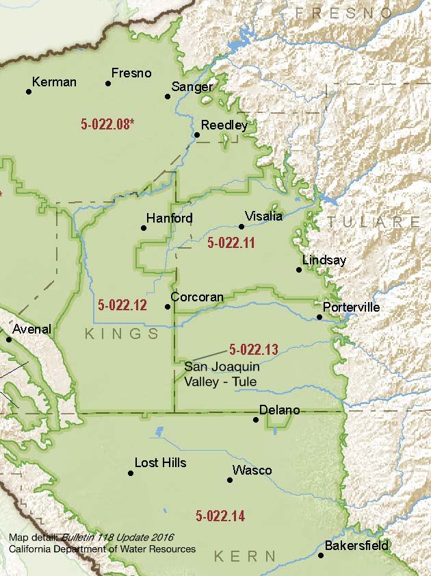
San Joaquin Valley – Tule
Statistics
- Basin Name
- San Joaquin Valley – Tule
- Basin Number
- 5-022.13
- SGMA Basin Priority
- High
- Critically Overdrafted
- Yes
- Hydrologic Region Name
- Tulare Lake
- Counties
- Tulare
Basin Notes
2003: Bulletin 118 basin description
2014: CASGEM basin prioritization – High
2016: Basin boundary modification accepted with San Joaquin Valley – Kern subbasin 5-022.14 Revised basin boundary description
2018: Phase 1 (FINAL) priority – High
2020: January 16: Coordination agreement between multiple Groundwater Sustainability Agencies (GSAS) producing multiple Groundwater Sustainability Plans (GSPS) for Tule Subbasin published Tule Subbasin GSAs Groundwater Sustainability Plans:
Delano Earlimart Irrigation District GSA (January 27, 2020); Tri-County Water Authority (December 18, 2019); Eastern Tule GSA (January 17, 2020); Lower Tule River Irrigation District GSA (January 21, 2020); Pixley Irrigation District GSA, January 21, 2020
2022: January – DWR deems the collective GSA’s GSP, “the plan,” to be incomplete. Shortcomings cited include failure to define undesirable results, set minimum thresholds, or comply with GSP regulations. GSAs given 180 days to submit revised plans.
July 27 – Pixley, Eastern Tule, Delano GSAs submit revised GSPs
2023: March 2 — DWR finds the revised GSPs inadequate.
May 2 – DWR refers GSAs to the State Water Resources Control Board
2024: September 17 — Tule Subbasin put on probationary status by the California State Water Resources Board ; Board chronology, references here
2025: April 17 — Extractor reports due February 1, 2026
At-A-Glance
California Water Library Documents About This Basin
Decadal Shifts in Groundwater Age Detected by Environmental Tracers Across California
American Geophysical Union (AGU) | March 23rd, 2026
Groundwater age tells us how long water has been underground since it last infiltrated the land surface. Monitoring changes in groundwater age helps identify aquifer stre
San Joaquin Valley Conveyance Study
California Department of Water Resources (DWR) | November 24th, 2025
This San Joaquin Valley Conveyance Study analyzes water conveyance needs in the San Joaquin Valley (Figure ES-1). The purpose of this study is to: •Describe the impa
2024 Annual Multibenefit Land Repurposing Program Report
California Department of Conservation (CDoC) | May 29th, 2025
The Multibenefit Land Repurposing Program (MLRP) increases regional capacity for repurposing irrigated agricultural land to uses that reduce reliance on groundwater while
Quantification of record-breaking subsidence in California’s San Joaquin Valley
Nature Portfolio (Springer Nature) | November 19th, 2024
Tule Subbasin Probationary Hearing Final Staff Report
California State Water Resources Control Board (SWRCB) | August 30th, 2024
Board staff identified specific deficiencies in the Tule Subbasin 2022 GSPs and outlined potential corrective actions to address those specific deficiencies. • Chron
Drought, water management, and agricultural livelihoods: Understanding human-ecological system management and livelihood strategies of farmer’s in rural California
Elsevier | July 11th, 2024
Second Amended Delano-Earlimart Irrigation District Groundwater Sustainability Plan 2024
Delano-Earlimart Irrigation District Groundwater Sustainability Agency (DEID GSA) | July 1st, 2024
In January of 2020, the DEID GSA submitted its Groundwater Sustainability Plan (GSP) to the California Department of Water Resources (DWR). The GSP provided technical doc
Tentative Ruling, Friant Water Authority vs. Eastern Tule Groundwater Sustainability Agency
Superior Court of California, County of Tulare | June 25th, 2024
CV-SALTS Groundwater Sustainability Plan Data Integration Report Integrated Scope of Work - Task 5.3 (Draft)
Central Valley Salinity Alternatives for Long-Term Sustainability (CV-SALTS) | June 20th, 2024
The purpose of Prioritization & Optimization (P&O) Study Task 5.3 (Information Extraction from Groundwater Sustainability Plans [GSP]) is to extract and organize
Replenishing Groundwater in the San Joaquin Valley: 2024 Update
Public Policy Institute of California (PPIC) | June 6th, 2024
Strategies to replenish groundwater basins—long used in some areas of the San Joaquin Valley—have increasingly come into focus as the region seeks to bring its overd
Status of Water Quality in Groundwater Resources Used for Drinking-Water Supply in the Southeastern San Joaquin Valley, 2013–15: California GAMA Priority Basin Project
U.S. Geological Survey (USGS) | April 25th, 2024
The California Groundwater Ambient Monitoring and Assessment Program Priority Basin Project (GAMA-PBP) investigated water quality of groundwater resources used for drinki
Tule Subbasin Probationary Hearing Draft Staff Report
California State Water Resources Control Board (SWRCB) | March 1st, 2024
The State Water Board recognizes that local public agencies in the Tule Subbasin significant efforts since the passage of SGMA to form groundwater sustainability agencies
Friant Water Authority vs. Eastern Tule Groundwater Sustainibilty Agency
Superior Court of California, County of Tulare | February 15th, 2024
Lower Tule River Irrigation District Groundwater Sustainability Plan San, Joaquin - Tule Subbasin
Lower Tule River Irrigation District Groundwater Sustainability Agency | July 19th, 2023
This Plan addresses the items identified in the SGMA regulations specific to the Agency, including descriptions of the physical characteristics, the water budget (histor
Statement of Findings regarding the Determination of Inadequate Status of the San Joaquin Valley Basin - Tule Subbasin Groundwater Sustainability Plan
California Department of Water Resources (DWR) | March 2nd, 2023
LandFlex Program’s Guidelines
California Department of Water Resources (DWR) | December 8th, 2022
LandFlex is a program that will provide $25 million in block grants to local government agencies to grant to farmers who limit agricultural water use. Local government ag
Modeling the dynamic penetration depth of post-1950s water in unconfined aquifers using environmental tracers: Central Valley, California
Journal of Hydrology (Elsevier) | December 5th, 2022
The penetration depth of post-1950s recharge (D-1950) in aquifers is a marker that is frequently used to identify groundwater that is susceptible to anthropogenic contami
Pixley Irrigation District Groundwater Sustainability Plan (Revised)
Pixley Irrigation District Groundwater Sustainability Agency (PIDGSA) | July 27th, 2022
The Tule Subbasin is designated by DWR as a critically overdrafted basin with an estimated subbasin average overdraft of 115,300 acre-feet per year. The Agencies estimat
Updated Groundwater Sustainability Plan, San Joaquin Valley – Tule, Alpaugh Groundwater Sustainability Agency
Alpaugh Groundwater Sustainability Agency | July 27th, 2022
Alpaugh GSA is part of the Tule Subbasin and was formed in May 2016 for the purpose of complying with the SGMA. This updated GSP complies with the SGMA by addressing the
Amended Groundwater Sustainability Plan, Tri-County Water Authority - Tule Subbasin
Tri-County Water Authority | July 27th, 2022
The Tule Subbasin submitted six GSPs, including one for the Tri-County Water Authority, in January 2020 to the Department of Water Resources (DWR). DWR was required to de