Sacramento Valley – Colusa
Statistics
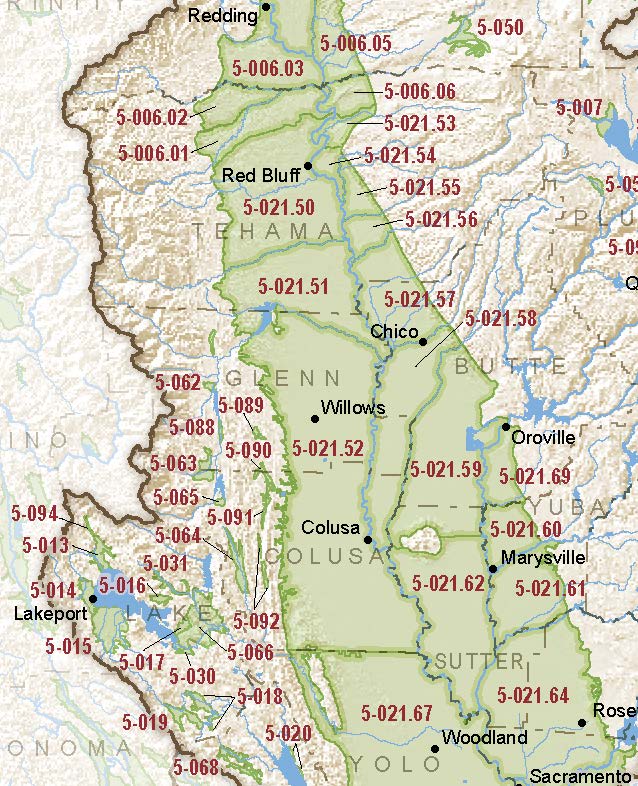
- Basin Name
- Sacramento Valley – Colusa
- Basin Number
- 5-021.52
- SGMA Basin Priority
- High
- Critically Overdrafted
- No
- Hydrologic Region Name
- Sacramento River
- Counties
- Colusa, Glenn, Plumas, Tehama, Yolo
- Adjacent Basins
Basin Notes
2003: Bulletin 118 basin description
2014: Basin prioritization – medium. Comments: Severely declining GW levels along the west-side of Glenn Co. Moderately declining GW levels in the Capay area. High TDS shallow aquifer in Maxwell- Williams area. Increase in housing development along I5. GW-SW interaction is important to maintaining waterfowl refuges. Area is being highlighted as solution area for Delta outflow issues…proposed increase in CU and GW pumping.
2016: Basin boundary modification
Revised basin boundary description
2018: Priority – high Per 2018 draft basin prioritization: Groundwater-related transfer “Type A” in which local groundwater is pumped to compensate for exported supply Butte County basin boundary/consolidation request for Colusa and the Wyandotte Creek 5-021.69, Corning 5-021.51, Vina 5-021.57, West Butte 5-021.58, East Butte 5-021.59, Sutter 5-021.62 subbasins pending Basin boundary modification approved. Per DWR: It “revises the central-easterly boundary of the Colusa and West Butte subbasins to extend easterly to follow the western boundary of Reclamation District 1004. The revision places the Colusa Groundwater Authority wholly within the Colusa subbasin.” Phase 2 draft priority: high.
2022: January 28 – Groundwater Sustainability Plan submitted to DWR
2023: October 26 – DWR assessed the plan incomplete and gave the GSA 180 days to correct deficiencies.
December 11 – Addressing Groundwater Overdraft in the Sacramento Valley, Public Policy Institute of California
At-A-Glance
California Water Library Documents About This Basin
Assessing Causes and Consequences of Winter Surface Water Dynamics in California's Central Valley Using Satellite Remote Sensing
Wiley Online Library | June 3rd, 2025
California's Central Valley is increasingly vulnerable to winter floods. A comprehensive spatial baseline of flood extents is critical for inundation analyses that can en
A Conservation Footprint for California Rice
California Rice Commission (CRC) | January 31st, 2025
Rice agriculture, especially winter-flooded rice fields, provides surrogate wetlands that host a diversity of species in the Central Valley. Rice fields are critical for
Groundwater sustainability and land subsidence in California’s Central Valley
Water (MDPI) | April 22nd, 2024
The Central Valley of California is one of the most prolific agricultural regions in the world. Agriculture is reliant on the conjunctive use of surface-water and groundw
Statement of Findings Regarding the Determination of Incomplete Status of the Sacramento Valley – Colusa Subbasin Groundwater Sustainability Plan
California Department of Water Resources (DWR) | October 26th, 2023
Thousands of domestic and public supply wells face failure despite groundwater sustainability reform in California’s Central Valley
Nature Portfolio (Springer Nature) | September 8th, 2023
Subsurface water flux in California's Central Valley and its source watershed from space geodesy
American Geophysical Union (AGU) | September 29th, 2022
We combine measurements from Global Positioning System positioning and Gravity Recovery and Climate Experiment gravity to infer change in water components in Central Vall
Colusa Subbasin Groundwater Sustainability Plan
Colusa Groundwater Authority | December 3rd, 2021
The purpose of this GSP is to characterize groundwater conditions in the Subbasin, evaluate and report on existing conditions relating to the six sustainability indicator
Multiscale Assessment of Agricultural Consumptive Water Use in California's Central Valley
American Geophysical Union (AGU) | May 4th, 2021
Hydrology, Hydraulics, and Water Management Technical Report
U.S. Bureau of Reclamation (USBR) | December 15th, 2014
This Technical Report describes pertinent hydrologic and hydraulic condition and water management operations for Shasta Lake, the Sacramento River, the Delta, and the CVP
Sutter County Groundwater Management Plan
Sutter County | March 19th, 2012
Sutter County intends this GMP to be relevant for the entire County. Sutter County overlies the south central part of the Sacramento Valley Groundwater Basin, and specif
Ground-Water Quality Data in the Middle Sacramento Valley Study Unit, 2006—Results from the California GAMA Program
U.S. Geological Survey (USGS) | July 15th, 2008
Ground-water quality in the approximately 3,340 mi2 Middle Sacramento Valley study unit (MSACV) was investigated from June through September, 2006, as part of the Califor
Stony Creek Fan Conjunctive Water Management Plan Feasibility Investigation
Glenn-Colusa Irrigation District | February 15th, 2004
Late Cenozoic Tectonism of the Sacramento Valley, California
U.S. Geological Survey (USGS) | July 15th, 1987
Geochemistry of Ground Water in the Sacramento Valley, California
U.S. Geological Survey (USGS) | July 13th, 1984
A geochemical investigation was done to evaluate temporal changes in water quality and to determine the processes that control water chemistry in shallow ground water of
Bulletin No. 58 Northeastern Counties Investigation
California Department of Water Resources (DWR) | December 3rd, 1957