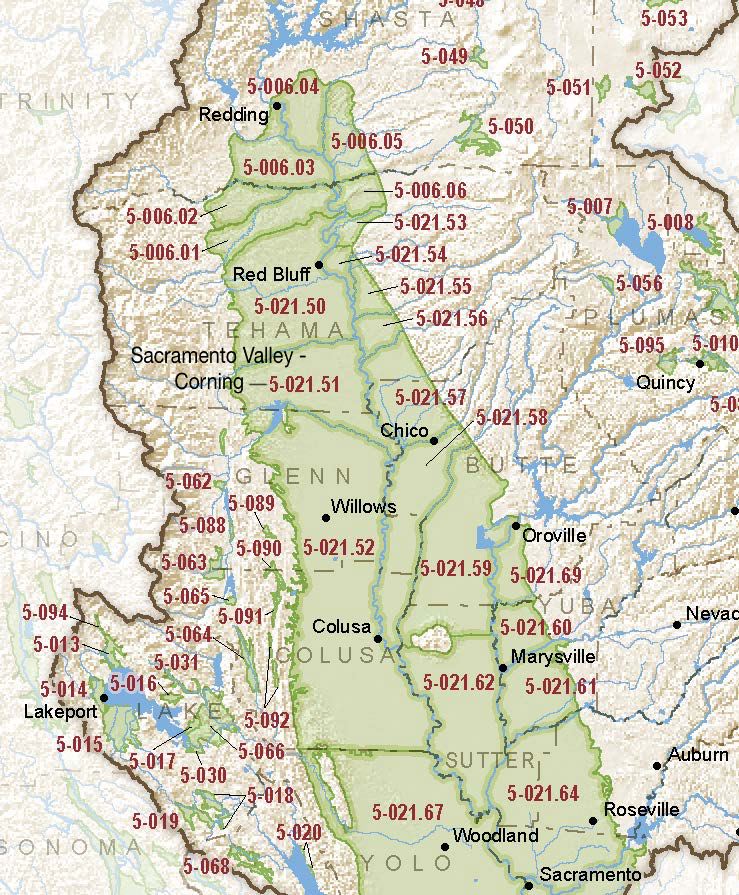
Sacramento Valley – Corning
Statistics
- Basin Name
- Sacramento Valley – Corning
- Basin Number
- 5-021.51
- SGMA Basin Priority
- High
- Critically Overdrafted
- No
- Hydrologic Region Name
- Sacramento River
- Counties
- Glenn, Tehama
Basin Notes
2003: Bulletin 118 basin description
2014: Basin Prioritization – medium.
2016: Basin boundary modification
Revised basin boundary description
2018: Basin prioritization – medium Butte County basin boundary/consolidation request for Corning and the Wyandotte Creek 5-021.69, Colusa 5-021.52, Vina 5-021.57, West Butte 5-021.58, East Butte 5-021.59, Sutter 5-021.62 subbasins pending 2019: Basin boundary modification approved. Per DWR: It “consists of four parts. The first part revises and expands the Vina subbasin to cover groundwater dependent areas currently included in the northern portions of East Butte and West Butte subbasins. The modification extends the Butte County portion of Vina Subbasin southerly to the northern boundary of Western Canal Water District. The resulting Vina subbasin includes the City of Chico, unincorporated Durham, and the Durham Irrigation District. The second part modifies the western boundaries of the existing Butte County portion of Vina, and West Butte subbasins, near the Sacramento River to align with the Butte County line. The third part revises the southern boundary of the East Butte subbasin to follow the Butte/Sutter County line except for the Biggs-West Gridley Water District and Reclamation District 1004 jurisdictional boundaries; which results in these Districts being entirely within the resulting Butte subbasin. The fourth part consolidates the remaining East Butte and West Butte subbasin areas to form the Butte subbasin. ” Phase 2 draft priority: high
2022: January 28 – Groundwater Sustainability Plan (GSP) submitted to the Department of Water Resources (DWR)
2023: October 26 – GSP deemed incomplete by DWR. County of Glenn Groundwater Sustainability Agency – Corning given 180 days to submit a revised plan.
December 11 — Addressing Groundwater Overdraft in the Sacramento Valley – Public Policy Institute of California
At-A-Glance
California Water Library Documents About This Basin
Assessing Causes and Consequences of Winter Surface Water Dynamics in California's Central Valley Using Satellite Remote Sensing
Wiley Online Library | June 3rd, 2025
California's Central Valley is increasingly vulnerable to winter floods. A comprehensive spatial baseline of flood extents is critical for inundation analyses that can en
Statement of Findings Regarding the Approval of the Sacramento Valley – Corning Subbasin 2024 Groundwater Sustainability Plan
California Department of Water Resources (DWR) | February 27th, 2025
Groundwater sustainability and land subsidence in California’s Central Valley
Water (MDPI) | April 22nd, 2024
The Central Valley of California is one of the most prolific agricultural regions in the world. Agriculture is reliant on the conjunctive use of surface-water and groundw
Statement of Findings regarding the Determination of Incomplete Status of the Sacramento Valley – Corning Subbasin Groundwater Sustainability Plan
California Department of Water Resources (DWR) | October 26th, 2023
Thousands of domestic and public supply wells face failure despite groundwater sustainability reform in California’s Central Valley
Nature Portfolio (Springer Nature) | September 8th, 2023
Subsurface water flux in California's Central Valley and its source watershed from space geodesy
American Geophysical Union (AGU) | September 29th, 2022
We combine measurements from Global Positioning System positioning and Gravity Recovery and Climate Experiment gravity to infer change in water components in Central Vall
Corning Subbasin Groundwater Sustainability Plan
Tehama County Flood Control and Water Conservation District | December 20th, 2021
Preparation of this GSP is the first step for the GSAs to achieve groundwater sustainability in the Corning Subbasin. To evaluate progress toward groundwater sustainabili
Critical Aquifer Overdraft Accelerates Degradation of Groundwater Quality in California's Central Valley During Drought
American Geophysical Union (AGU) | September 1st, 2021
It has been established that wells are at risk to run dry when groundwater levels decline during drought, but associated impacts to water quality are poorly understood.
Multiscale Assessment of Agricultural Consumptive Water Use in California's Central Valley
American Geophysical Union (AGU) | May 4th, 2021
Groundwater quality in the Redding–Red Bluff shallow aquifer study unit of the northern Sacramento Valley, California
U.S. Geological Survey (USGS) | April 23rd, 2020
This study was designed to provide a statistically representative assessment of the quality of groundwater resources used for domestic drinking water in the Redding–
Domestic well vulnerability to drought duration and unsustainable groundwater management in California's Central Valley
Environmental Research Letters (IOP) | March 18th, 2020
Millions of Californians access drinking water via domestic wells, which are vulnerable to drought and unsustainable groundwater management. Groundwater overdraft and th
A hybrid machine learning model to predict and visualize nitrate concentration throughout the Central Valley aquifer, California, USA
Science of the Total Environment (Elsevier) | June 9th, 2017
Intense demand for water in the Central Valley of California and related increases in groundwater nitrate concentration threaten the sustainability of the groundwater res
Hydrology, Hydraulics, and Water Management Technical Report
U.S. Bureau of Reclamation (USBR) | December 15th, 2014
This Technical Report describes pertinent hydrologic and hydraulic condition and water management operations for Shasta Lake, the Sacramento River, the Delta, and the CVP
Ground-Water Quality Data in the Middle Sacramento Valley Study Unit, 2006—Results from the California GAMA Program
U.S. Geological Survey (USGS) | July 15th, 2008
Ground-water quality in the approximately 3,340 mi2 Middle Sacramento Valley study unit (MSACV) was investigated from June through September, 2006, as part of the Califor
Geochemistry of Ground Water in the Sacramento Valley, California
U.S. Geological Survey (USGS) | July 13th, 1984
A geochemical investigation was done to evaluate temporal changes in water quality and to determine the processes that control water chemistry in shallow ground water of