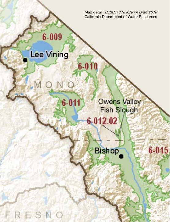
Owens Valley – Fish Slough
Statistics
- Basin Name
- Owens Valley – Fish Slough
- Basin Number
- 6-012.02
- SGMA Basin Priority
- Very Low
- Critically Overdrafted
- No
- Hydrologic Region Name
- South Lahontan
- Counties
- Mono
- Adjacent Basins
Basin Notes
Fish Slough was included as an independent groundwater basin in Bulletin 118 (DWR, 1975) and Bulletin 118-80 (DWR, 1980), but dropped from Bulletin 118-2003 (DWR, 2003) on the reasoning that “Granite Mountain Area (6-59) and Fish Slough Valley (6-60) groundwater basins have been deleted because no information was found concerning wells or groundwater in these basins or because well completion reports indicate that groundwater production is derived from fractured rocks beneath the basin.” Shallow cores from Fish Slough show alluvium is a thin veneer on the order of ten feet atop Bishop Tuff. — Hydrogeologic Conceptual Model for the Owens Valley Groundwater Basin (6-12), Inyo and Mono Counties by Robert Harrington
Fish Slough – Area of Critical Environmental Concern – Bureau of Land Management (BLM)
2016: Basin boundary request by Owens Valley 6-012.01 denied
2018: Final Basin Prioritization: Very Low.
At-A-Glance
California Water Library Documents About This Basin
Off-Lake Sources of Airborne Dust in Owens Valley, California
National Academy of Sciences (NAS) | June 17th, 2025
Since 2017, the District has used additional information to attribute PM10 exceedances to specific sources within the Owens Valley Planning Area. This information include
Incomplete Determination for Groundwater Sustainability Plan submitted for Owens Valley Subbasin (Basin No. 6-012.01)
California Department of Water Resources (DWR) | April 14th, 2025
Annual Owens Valley Operations Plan for the 2024-25 Runoff Year
Los Angeles Department of Water & Power (LADWP) | June 20th, 2024
California’s Sustainable Groundwater Management Act and the Half-Exemption of Owens Valley Groundwater Basin
University of California, Los Angeles (UCLA) | May 1st, 2024
This Comment first uses historical accounts and secondary sources to describe the history of Owens Valley groundwater. It next describes the Governing Documents that curr
One Water LA 2040 Plan
City of Los Angeles | April 30th, 2018
The purpose of the One Water LA 2040 Plan (Plan) is to increase sustainable water management for the City of Los Angeles (City). The City launched One Water LA with two p
Los Angeles Department of Water and Power 2018 Annual Owens Valley Report
Los Angeles Department of Water & Power (LADWP) | December 1st, 2017
This report includes Los Angeles Department of Water and Power’s (LADWP) proposed Owens Valley Operations Plan for the 2018-2019 Runoff Year, an update on Owens Valley
Extreme hydrological changes in the southwestern US drive reductions in water supply to Southern California by mid century
Environmental Research Letters (IOP) | September 21st, 2016
The Southwestern United States has a greater vulnerability to climate change impacts on water security due to a reliance on snowmelt driven imported water. The State of C
Hydrogeologic Conceptual Model for the Owens Valley Groundwater Basin (6-12), Inyo and Mono Counties
Inyo County Water Department (ICWD) | January 27th, 2016
This report provides a hydrogeologic conceptual model of the Owens Valley Groundwater Basin (OVGB) compiled from numerous sources including the US Geological Survey, Los
Los Angeles Department of Water and Power 2016 Annual Owens Valley Report
Los Angeles Department of Water & Power (LADWP) | December 1st, 2015
This report includes Los Angeles Department of Water and Power’s (LADWP) proposed Owens Valley operations plan for the first six months of the 2016-17 runoff year, an u
California Water Plan Update 2013: South Lahontan Hydrologic Region Report
California Department of Water Resources (DWR) | October 30th, 2014
Several of California’s well-known natural resources are located in the South Lahontan Hydrologic Region. They include Mono Lake, Death Valley, the Owens Valley, and th
Evaluation of the Hydrologic System and Selected Water-Management Alternatives in the Owens Valley, California
U.S. Geological Survey (USGS) | May 9th, 2000
The Owens Valley, a long, narrow valley along the east side of the Sierra Nevada in east-central California, is the main source of water for the city of Los Angeles. The
The Alkaline and Boracic Lakes of California
Scientific American | July 7th, 1877
Immediately east of the range of the Sierra Nevada is an extensive region of alkaline lakes and hot springs, of which very large areas are almost totally barren, the onl