 Declines in groundwater storage are an indication that more groundwater is leaving the system through groundwater pumping, subsurface flows, evapotranspiration or other factors, than is entering the system via natural or artificial recharge, subsurface flows, precipitation, or other sources.
Groundwater storage is a term used to refer to the amount of usable water that remains in an aquifer. Significant and reasonable declines in the amount of groundwater storage may threaten the aquifer’s ability to “produce” or provide water long-term.
Changes in groundwater levels in different aquifers can serve as good proxy for changes in groundwater storage over time. Thus, as discussed in groundwater level declines, it is important that GSAs develop groundwater monitoring networks to sufficiently track changes in groundwater levels and understand how their system responds to changes conditions.
Well-developed and calibrated groundwater models can help water managers understand how changes in pumping, land use or other variables may impact groundwater storage long-term. These models rely on long-term groundwater level data for calibration.
NASA’s Gravity Recovery and Climate Experiment (GRACE) satellites can provide estimates of changes in groundwater storage. However, satellite estimates should be used cautiously, as they are more regional in nature and do not provide the level of accuracy necessary to fully determine the conditions at the basin-scale. Land-based gravity methods can measure changes in groundwater storage locally and are more accurate than satellite estimates; however, these methods must be calibrated using local groundwater monitoring networks.
FOR MORE INFORMATION: USGS webpage for groundwater storage declines
Key information
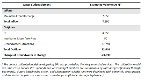
Groundwater extraction far exceeding recharge by pistachio and alfalfa farmers in the Mojave Desert has not only mined the aquifer but also destroyed its recharge capacity. When it published its Groundwater Sustainability Plan in early 2020, the Indian Wells Valley Groundwater Sustainability Agency estimated, “Currently (2011 to 2015), outflows are approximately four times the estimated inflows. The magnitude of the overdraft results in an average annual loss of storage of approximately 25,000 AFY, losing 25,000 acre feet of storage capacity every year.”

Projecting groundwater storage changes in California’s Central Valley
Accurate and detailed knowledge of California’s groundwater is of paramount importance for statewide water resources planning and management, and to sustain a multi-billion-dollar agriculture industry during prolonged droughts. In this study, we use water supply and demand information from California’s Department of Water Resources to develop an aggregate groundwater storage model for California’s Central Valley. The model is evaluated against 34 years of historic estimates of changes in groundwater storage derived from the United States Geological Survey’s Central Valley Hydrologic Model (USGS CVHM) and NASA’s Gravity Recovery and Climate Experiment (NASA GRACE) satellites. The calibrated model is then applied to predict future changes in groundwater storage for the years 2015–2050 under various precipitation scenarios from downscaled climate projections. We also discuss and project potential management strategies across different annual supply and demand variables and how they affect changes in groundwater storage. All simulations support the need for collective statewide management intervention to prevent continued depletion of groundwater availability.

