From the Oroville Mercury Register:
“Butte County may soon have a better idea of what lies beneath its surface, thanks in part to the Kingdom of Denmark. Starting in late November, a helicopter took off for several days from the Orland airport to fly a pattern over an area between Chico and Orland, and southeast into Butte Valley. Dangling beneath the helicopter was a hoop loaded with devices that created a weak magnetic field and instruments that measured how that interacted with layers beneath the soil.
Christina Buck with the Butte County Department of Water and Resource Conservation explained that underground there are layers of sands and gravels that hold water, divided by layers of clay and silt that block water passage to different degrees. … ”
Read more from the Oroville Mercury-Register here: Butte County: Helicopter survey should aid groundwater planning
From Water in the West:
“Most areas of California farm country have a significant lack of information about their groundwater use. The water managers responsible for putting California’s depleted aquifers on the path to sustainability now need to get the data to do the job. Running the new agencies created under the state’s Sustainable Groundwater Management Act, these managers must first decide what they need to know, and how to get the information.
The measuring gauges they need would ideally give two different views of groundwater reality. First, account for withdrawals by identifying who is taking the water, then control the withdrawals to ensure sustainability, now required in 109 of the state’s 517 groundwater basins. Second, monitor the overall health of the aquifer to ensure it is not trespassing over the various boundaries of unsustainability now carved into state law. … “
To read this article, click here: As California’s Groundwater Free-for-All Ends, Gauging What’s Left
From the Harvard Gazette:
“Seismic noise — the low-level vibrations caused by everything from subway trains to waves crashing on the beach — is most often something seismologists work to avoid. They factor it out of models and create algorithms aimed at eliminating it so they can identify the signals of earthquakes.
But Tim Clements thinks it might be a tool to monitor one of the most precious resources in the world — water. A graduate student working in the lab of Assistant Professor of Earth and Planetary Sciences Marine Denolle, Clements is the lead author of a recent study that used seismic noise to measure the size and water levels in underground aquifers in California. … ”
Read more from The Harvard Gazette here: Study uses seismic noise to track water levels in underground aquifers
Data shows groundwater recharge in the region has declined by 1.1 MAF since 2000; storage remains at unhealthy levels
From Maven’s Notebook:
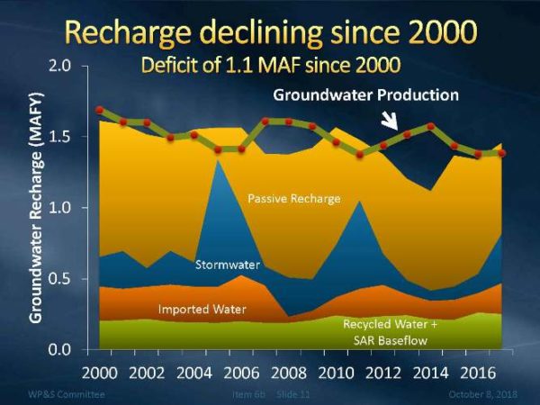 “At the October meeting of Metropolitan’s Water Planning and Stewardship Committee, Senior Engineer Matt Hacker updated the committee members on regional groundwater conditions, including groundwater production, recharge, and storage conditions.
There are 88 groundwater basins and subbasins within the Metropolitan service area. Groundwater provides over 1/3rd of the region’s water supplies. 89% of the basins within the Metropolitan service area either are adjudicated or managed. … “
Continue reading at Maven’s Notebook here: METROPOLITAN WATER DISTRICT: Update on Southern California regional groundwater conditions