 Land subsidence is the gradual settling of the Earth’s surface. Subsidence can be caused by a variety of factors; however, here in California, the primary causes are groundwater pumping and the decomposition of wetland soils after conversion to farmland. Groundwater extractions that deplete or “drain” confined aquifer systems can cause the sediments to compact and the land surface to sink (or subside).
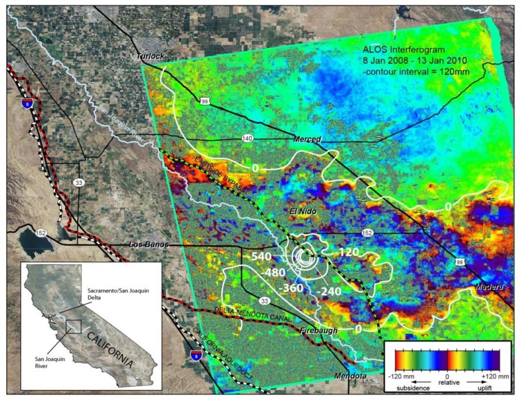
Extensive groundwater withdrawals from aquifer systems have caused land subsidence in many California basins. Land subsidence can damage structures such as wells, buildings, and highways.
For more information, click here to visit the USGS webpage for land subsidence.
Key information
Land subsidence: what is it and why is it an important aspect of groundwater management?
 Land subsidence is a gradual settling or sudden sinking of the Earth’s surface due to the movement of earth materials. Some serious effects of land subsidence include loss of levee freeboard and subsequent reduction in flood protection, change of gradient along water conveyance canals, damage to roads and bridges, and the collapse of water well casings. Understanding and detecting land subsidence in very early stages is important to prevent these types of structural damage.
This article discusses land subsidence including methods for measuring land subsidence.
Land Subsidence: The Lowdown on the Draw-down
The link between groundwater use and sinking landscape
The Westside Subbasin Groundwater Sustainability Plan addressed a self-inflicted problem: How to check the subsidence caused by its own groundwater pumping when that subsidence also threatens the canal delivering its surface water imports? Its response: “It is possible that the combination of other measures will not be sufficient individually or collectively to avoid significant and unreasonable land subsidence. When combined with cumulative Subbasin pumping, groundwater withdrawals near Checks 16, 17, and 20 of the San Luis Canal/California Aqueduct, may require focused management efforts. Consequently, the GSP proposes to offer or, if necessary to avoid significant and unreasonable land subsidence, to require surface water substitution to reduce groundwater pumping near the Canal. In exchange for the reduction in pumping, the GSA may provide incentives to landowners included in this program. Participating landowners may be required to bear material unmitigated impacts in accepting the substitute surface water.”

USGS Tool: Land subsidence in California
 With this mapping tool from the USGS, explore the areas of historical and current land subsidence across California.
Land subsidence articles on Maven’s Notebook
[cm_rss_aggregator list=”land subsidence”]Explore land subsidence at the California Water Library
{{ document.post_title }}
{{ document.publisher }} | {{ document.document_date }}
{{ document.post_content_short }}