GSA SUMMIT: Setting Sustainable Management Criteria: It’s easy, isn’t it?

The details of how a groundwater sustainability plan will be implemented are defined by the setting of sustainable management criteria (or SMC). With several undesirable results to consider, a range of technical analyses to perform, data gaps yet to be filled, and potentially conflicting stakeholder interests, the process to establish sustainable management criteria is often involved and challenging.

At the Groundwater Resources Association’s 3rd annual GSA Summit, a panel reviewed how the process went for the groundwater sustainability plans that were submitted to the Department of Water Resources earlier this year, focusing on four of the six sustainable management criteria: water levels, water quality, land subsidence, and interconnected surface waters.

Click here to read this article at Maven’s Notebook.

Location, location, location: New tool shows where groundwater recharge will maximize benefits

From the Environmental Defense Fund:

Recharging groundwater with rain and snowmelt is one strategy water managers are embracing to help balance groundwater supply and demand and comply with the California Sustainable Groundwater Management Act.

Depending on the location, recharge can also deliver other valuable benefits, such as additional habitat for wildlife and a more resilient water supply for people.

With support from EDF, four UC Santa Barbara graduate students have developed a new mapping tool for California’s Central Valley to identify the best locations for groundwater recharge to secure these bonus benefits.

Click here to continue reading at Growing Returns.

WEBINAR RECORDING: : Tools for Evaluating Drinking Water Needs in SGMA

If you missed the recent webinar on tools for evaluating drinking water needs in SGMA, you can watch it now online:
Webinar information:
Resources discussed by the panelists:

GSA SUMMIT: Lessons learned from the 2020 GSPs: Perspectives from the critically overdrafted basins

The implementation phase of the Sustainable Groundwater Management Act has now begun for the basins designated as critically-overdrafted. Getting to this point has been an unparalleled journey as communities, farmers, water suppliers, and others navigated through uncharted territory to develop local solutions for sustainable groundwater management. At the Groundwater Resources Association Third Annual Groundwater Sustainability Agency Summit held online in June, a panel of managers from four of the critically overdrafted basins reflected on the hard work of developing and adopting a groundwater sustainability plan.

Seated on the panel were Gary Petersen from the Salinas Valley Basin GSA; Eric Osterling from the Mid Kaweah GSA; Deanna Jackson from TriCounty GSA; and Patricia Poire from the Kern Groundwater Authority.  Collectively, these GSAs are having to deal with all six of the undesirable results, from subsidence to groundwater levels to seawater intrusion, and they overly five of the 21 critically overdrafted basins.

Each panelist then discussed the process that they went through in developing their plans, the lessons they learned, and their advice for those developing the plans that will be due in January of 2022.

Click here to read this article.

GSA SUMMIT: Reflections on the 2020 GSP process

At the end of January of this year, the state’s critically overdrafted groundwater basins submitted their adopted groundwater sustainability plans (or GSPs), meeting an important deadline in the Sustainable Groundwater Management Act; the remaining basins subject to SGMA will be submitting their plans in January of 2022.  The Department of Water Resources will now have two years to review the plans to determine their adequacy.

At the Third Annual GSA Summit, Craig Altare, chief of the Groundwater Sustainability Plan section at the Department of Water Resources’ Sustainable Groundwater Management Office or SGMO, reflected on the GSPs and how the implementation of SGMA is playing out.

Click here to read this article at Maven’s Notebook.


UPDATED TOOL: New features added to Water Tracker, a tool that displays the distribution of surface water across the Central Valley

From Point Blue Conservation Service:

With summer in full swing, it may be time to begin evaluating plans for the coming fall and winter seasons. If you are interested in learning more about the distribution of surface water across the Central Valley both in the past and in near real-time, we invite you to explore some exciting new features at Water Tracker – www.pointblue.org/watertracker

Explore wetland vegetation. Recent work by USGS provides annual maps of wetland vegetation across the Central Valley.

Two layers are available:

Wetland vegetation type, aka moist soil seed plants (swamp timothy, watergrass, cocklebur, etc.)
Habitat structure (tall emergent, open water, bare ground, etc.)

These data (2007-2017) are now available for viewing and downloading from the Map Viewer in Water Tracker. Learn more about from a recent publication led by Kristin Byrd at USGS.

Summaries of water from custom areas. You can now upload a shapefile or draw a custom spatial area and then, both download the data, AND get a summary of water in that area over time with interactive time-series plots. See an example here.

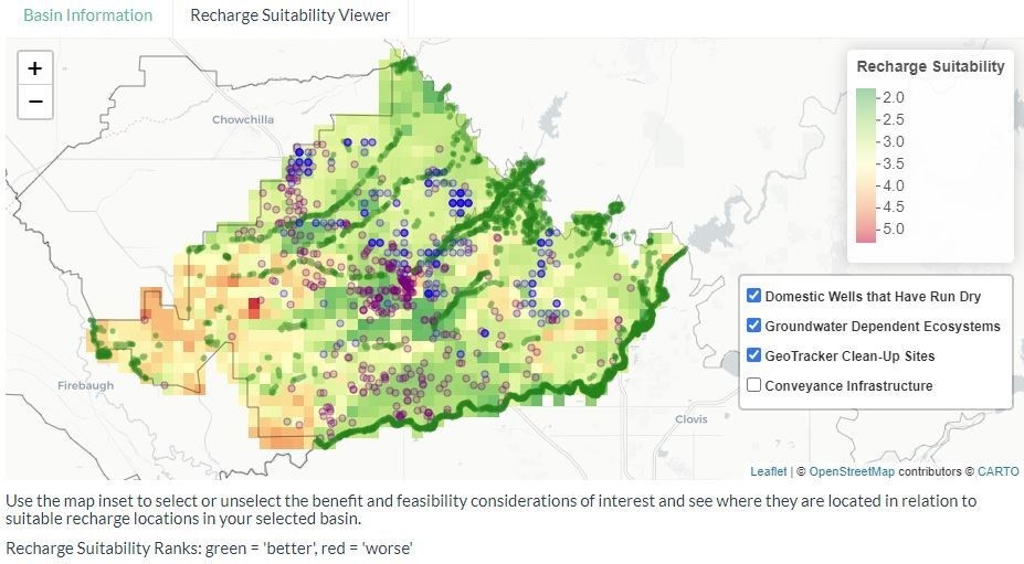
Coming soon. In the next several months we plan to make more data layers available including fallow fields (2000-2017), bird distribution/suitability (4 shorebirds, 4 waterfowl), giant garter snake distribution/suitability, groundwater recharge (based on Basin Characterization Model) and more!

What do managers need?

At the Central Valley Wetland Managers meeting in March, we shared spatial data we are currently developing, including fallow fields, wetland vegetation and types, groundwater recharge potential, bird and snake distribution/suitability maps, as well as some of the forecasting tools (within-year and long-term) in development.

A survey of participants in the meeting resulted in helpful feedback:

(1) most wetland managers’ first priority is their wetland complex
(2) for data to be most helpful for decision-making it should be made available in February/March and July/August, and
(3) visualizations and semi-custom summaries and/or reports appear to be the most appealing at this point.

We want these data and technologies to be useful and help wetland managers do their jobs, so we will be working to make sure that Water Tracker can deliver on these needs for wetland managers. Any feedback from the community is welcome. Email us at watertracker@pointblue.org to let us know what you need.

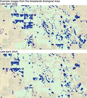
How is 2020 looking so far?

Overall, based on data from Water Tracker, the first 5 months of 2020 had, on average, 10% lower open water than the 2013-2019 average for these months. Only April had more open on the landscape water than the previous 7-year average and February had the lowest with a 17% reduction from average conditions. This is not surprising given the dry spell this winter. The estimated extent of open water in seasonal wetlands was also lower (-5%) across the first 5 months of 2020 compared to the recent 7-year average.

What is Water Tracker?

As a reminder, Water Tracker uses Landsat satellite imagery to update the distribution of open surface water in the Central Valley. It’s refreshed every 16 days. Water Tracker displays where open surface water is in the Central Valley in map form and also provides data summaries.

Anyone can quickly and easily get a picture of where the water is and isn’t, now and in the recent past. Data are available starting in 2013 (as far back as 2000 can be requested). Data can also be downloaded directly from Water Tracker.

There are a multitude of ways these data can inform decisions. Recent examples include 1) using the tool to decide on the best places to add water for the millions of waterbirds that rely on the Central Valley, and 2) to better understand the impacts of extreme drought on waterbird habitat availability.

Tell us how you are using Water Tracker

Please share your stories with us about how you are using Water Tracker at watertracker@pointblue.org. The best way for us to support this free, open-source resource is through understanding and highlighting how it is most useful.

Thank you for using and sharing Water Tracker in an effort to work towards meeting the water needs of both wildlife and people.

Click here for the Water Tracker Tool.

WATER WRIGHTS: San Luis-Delta Mendota WA, Semitropic WSD, Kern Water Bank, Friant WA, Westlands, and more …

A recap of what’s recently been posted at Water Wrights, a website that covers Central Valley water meetings:

Click here to read all articles at WaterWrights.net.


GROUNDWATER 101: The basics

Dr. Thomas Harter provides a basic understanding of groundwater – what it is, how much groundwater is out there, how fast groundwater moves, and where it comes from and where it goes

Groundwater is an important part of California’s – and the nation’s water supply.   Nationwide, groundwater makes up on average 26% of the water supply.  In California, that number is significantly higher – groundwater provides nearly 40% of the water used by California’s farms and cities, and significantly more in dry years.  But what is groundwater?  In this post based on the first segment of the UC Davis shortcourse on groundwater, Dr. Thomas Harter, who is the Robert M. Hagan Endowed Chair for Water Resources Management and Policy at the University of California, Davis as well as Professor and Cooperative Extension Specialist in the Department of Land, Air, and Water Resources (among many other things), provides a basic understanding of groundwater – what it is, how much groundwater is out there, how fast groundwater moves, and where it comes from and where it goes.

Click here to read this article.

How to Address Groundwater Planning Gaps

Ellen Hanak and Jelena Jezdimirovic write:

In these extraordinary times, managing groundwater for long-term sustainability may not seem like a top priority. But in the San Joaquin Valley—where groundwater supplies have been declining for decades—excess pumping is a critical problem, with major implications for public health, jobs, the environment, and local economies.

The state’s Sustainable Groundwater Management Act (SGMA) requires groundwater planning and actions to sustain this vital resource. Agencies from California’s 21 “critically overdrafted” basins—including 11 large basins that span most of the San Joaquin Valley floor—submitted their first groundwater plans in January.

As part of our long-term work to build shared understanding of water challenges and solutions in the valley, the Public Policy Institute of California reviewed the 36 plans developed for these basins to see how well they tackle some key issues.

Click here to continue reading at the PPIC.

The Past, Present and Future of California’s Groundwater

From Stanford’s Water in the West program:

A century after the state began overseeing surface water, the California legislature enacted a set of three laws regulating water below the surface. The passage of the Sustainable Groundwater Management Act (SGMA) in 2014, granted the state official oversight authority of groundwater. However, its involvement existed long before SGMA and continues to influence current policies and regulation of the resource. A new paper published in Society and Natural Resources, examines how the state’s ongoing involvement helped shape current policies by looking at the 120-year history of California’s role in groundwater management and policy development.

Below, study lead Evan Dennis and co-author Tara Moran, discuss the state’s changing role from supporting to mandating groundwater management. Dennis is a research associate at the Center for the Analysis of Social-Ecological Landscapes at Indiana University, Bloomington and Moran is a research associate and sustainable groundwater lead at Stanford’s Water in the West program.

Click here to read this article.