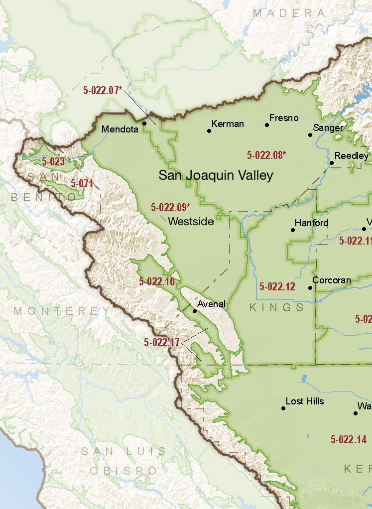
San Joaquin Valley – Westside

Statistics

Basin Notes

2003: Bulletin 118 basin description

2014: CASGEM basin prioritization – high

2016: Basin boundary modifications approved with Kings 5-022.08, Madera 5-022.06, Delta-Mendota 5-022.07 and Tracy 5-022.15 subbasins An amended, approved modification was also made with the border of Pleasant Valley subbasin 5-022.09

Revised basin boundary description

2018: Draft priority : High. Groundwater level and subsidence comments:

  • CRITICAL OVERDRAFT. 1) CASGEM/WDL/GWIDS: No data or data insufficent to determine GWL status. Source: DWR 2) The canal, now considered the middle section of the California Aqueduct, passes through three major subsidence bowls: 1) southwest of Mendota, 2) near the town of Cantua Creek, and 3) near the town of Huron (Ireland and others, 1984). Because subsidence due to groundwater extraction had adversely affected the earlier-built Delta-Mendota Canal, designers incorporated as much as 10 feet of extra freeboard into the San Luis Canal, adding $30.7 million (2013 dollars) to construction costs. Sources: Land Subsidence from Groundwater Use in California, James W. Borchers, Michael Carpenter, Luhdorff & Scalmanini, California Water Foundation, April, 2014  2) Current Land Subsidence in the San Joaquin Valley, USGS; 3) Progress Report: Subsidence in the Central Valley, California, Jet Propulsion Laboratory, California Institute of Technology, NASA 2015-16

Final Basin Prioritization: High.

2020:

2022:

2023: October 26 – DWR approved the GSP

2024: July 31 – US Fish and Wildlife Service releases the 15-year plan, the San Luis National Wildlife Refuge Complex Final Comprehensive Conservation Plan and Environmental Assessment

At-A-Glance

Source: CA DWR
Source: CA DWR

California Water Library Documents About This Basin

2024 Annual Multibenefit Land Repurposing Program Report

California Department of Conservation (CDoC) | May 29th, 2025

The Multibenefit Land Repurposing Program (MLRP) increases regional capacity for repurposing irrigated agricultural land to uses that reduce reliance on groundwater while

View Document Download

The State Water Project Delivery Capability Report 2023 Addendum - Impacts of Subsidence

California Department of Water Resources (DWR) | May 7th, 2025

The purpose of this addendum is to show how ongoing subsidence effects on the California Aqueduct will impact operation of the State Water Project (SWP). The addendum pro

View Document Download

Quantification of record-breaking subsidence in California’s San Joaquin Valley

Nature Portfolio (Springer Nature) | November 19th, 2024

View Document Download

San Luis National Wildlife Refuge Complex Final Comprehensive Conservation Plan and Environmental Assessment

U.S. Fish and Wildlife Service (FWS) | July 31st, 2024

This Comprehensive Conservation Plan (CCP) will guide the management of the Merced National Wildlife Refuge (NWR), San Luis NWR and Grasslands Wildlife Management Area (W

View Document Download

Drought, water management, and agricultural livelihoods: Understanding human-ecological system management and livelihood strategies of farmer’s in rural California

Elsevier | July 11th, 2024

View Document Download

Replenishing Groundwater in the San Joaquin Valley: 2024 Update

Public Policy Institute of California (PPIC) | June 6th, 2024

Strategies to replenish groundwater basins—long used in some areas of the San Joaquin Valley—have increasingly come into focus as the region seeks to bring its overd

View Document Download

Multibenefit Land Repurposing Program Annual Report 2023

California Department of Conservation (CDoC) | April 9th, 2024

The Multibenefit Land Repurposing Program (MLRP) increases regional capacity for repurposing irrigated agricultural land to uses that reduce reliance on groundwat

View Document Download

CV-SALTS Groundwater Sustainability Plan Data Collection - Pilot Study Results

Central Valley Salinity Alternatives for Long-Term Sustainability (CV-SALTS) | February 1st, 2024

The purpose of Prioritization & Optimization (P&O) Study Task 5.3 (Information Extraction from Groundwater Sustainability Plans [GSP]) is to extract and organize relevan

View Document Download

Statement of Findings regarding the Approval of the San Joaquin Valley – Westside Subbasin Groundwater Sustainability Plan

California Department of Water Resources (DWR) | October 26th, 2023

View Document Download

LandFlex Program’s Guidelines

California Department of Water Resources (DWR) | December 8th, 2022

LandFlex is a program that will provide $25 million in block grants to local government agencies to grant to farmers who limit agricultural water use. Local government ag

View Document Download

Modeling the dynamic penetration depth of post-1950s water in unconfined aquifers using environmental tracers: Central Valley, California

Journal of Hydrology (Elsevier) | December 5th, 2022

The penetration depth of post-1950s recharge (D-1950) in aquifers is a marker that is frequently used to identify groundwater that is susceptible to anthropogenic contami

View Document Download

Westside Subbasin Groundwater Sustainability Plan (Clarified and Amended GSP)

Westlands Water District | July 18th, 2022

Due to size, this file has been divided into 11 parts. Part 1, Part 2, Part 3, Part 4, Part 5, Part 6, Part 7, Part 8, Part 9, Part 10, Part 11

View Document Download

Statement of Findings regarding the Determination of Incomplete Status of the San Joaquin Valley - Westside Subbasin Groundwater Sustainability Plan

California Department of Water Resources (DWR) | January 21st, 2022

The Department of Water Resources (Department) is required to evaluate whether a submitted groundwater sustainability plan (GSP or Plan) conforms to specific requirements

View Document Download

Post-Drought Groundwater Storage Recovery in California's Central Valley

American Geophysical Union (AGU) | October 5th, 2021

California's Central Valley has experienced chronic groundwater depletion over the past few decades, the rate of which was amplified by droughts in 2007–2009 and 2012?

View Document Download

Groundwater development leads to decreasing arsenic concentrations in the San Joaquin Valley, California

Science of the Total Environment (Elsevier) | January 18th, 2021

In the San Joaquin Valley (SJV), California, about 10% of drinking water wells since 2010 had arsenic concentrations above the U.S. maximum contaminant level of 10μg/L.

View Document Download

Base of fresh water, groundwater salinity, and well distribution across California

National Academy of Sciences (NAS) | December 9th, 2020

The depth at which groundwaters transition from fresh to more saline—the “base of fresh water”—is frequently used to determine the stringency and types of measure

View Document Download

Divergent effects of climate change on future groundwater availability in key mid-latitude aquifers

Nature Portfolio (Springer Nature) | July 24th, 2020

Groundwater provides critical freshwater supply, particularly in dry regions where surface water availability is limited. Climate change impacts on GWS (groundwater stora

View Document Download

Westside Subbasin Groundwater Sustainability Plan

Westlands Water District | January 23rd, 2020

View Document Download

Report of Waste Discharge and Technical Report

Westlands Water District | July 10th, 2019

This Technical Report is in support of a Report of Waste Discharge (ROWD) for an agricultural aquifer storage and recovery (Ag-ASR) program for Westlands Water District

View Document Download

A hybrid machine learning model to predict and visualize nitrate concentration throughout the Central Valley aquifer, California, USA

Science of the Total Environment (Elsevier) | June 9th, 2017

Intense demand for water in the Central Valley of California and related increases in groundwater nitrate concentration threaten the sustainability of the groundwater res

View Document Download

GSA Information