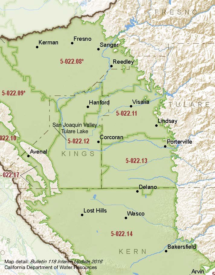
San Joaquin Valley – Tulare Lake
Statistics
- Basin Name
- San Joaquin Valley – Tulare Lake
- Basin Number
- 5-022.12
- SGMA Basin Priority
- High
- Critically Overdrafted
- Yes
- Hydrologic Region Name
- Tulare Lake
- Counties
- Kings
At-A-Glance
Located in California’s Tulare Lake hydrologic region, the San Joaquin Valley – Tulare Lake subbasin is 535,869 acres in size. This High priority basin is home to an estimated 535,870 people (2010 value). It has approximately 3906 wells, of which approximately 75 are water supply wells. Groundwater accounts for approximately 50.33 percent of the basin’s water supply.

Basin Notes
2003: Bulletin 118 basin description
2013: California Water Plan Update – Tulare Lake Hydrologic Region, Investing in Innovation and Infrastructure
2014: CASGEM basin prioritization – high. Comments: Subsidence, overdraft, water quality degradation
2016: Basin boundary modifications, Kaweah 5-022.11, Pleasant Valley 5-022.10, Tule Subbasin 5-022.13 Revised basin boundary description 2018: Draft priority – high. Groundwater level, salt intrusion, subsidence comments:
- CRITICAL OVERDRAFT 2016. 1) CASGEM/WDL/GWIDS: Longterm hydrographs show groundwater level decline. Source: DWR 2) Arid conditions and early agricultural development (pre-1900s) in the Tulare Lake Hydrologic Region have caused groundwater level declines, which have resulted in stream-aquifer dynamics. Under predevelopment conditions, groundwater-surface water interactions were very dynamic and depended on hydrologic conditions. Rapid growth in the agricultural sector in the Tulare Lake Hydrologic Region has resulted in groundwater development with increased groundwater pumping and subsequent groundwater level declines. In some areas of critical overdraft, such as in Kings and Kern counties, complete disconnection between groundwater and overlying surface water systems has occurred. Source: US Bureau of Reclamation, Program Draft EIR/EIS, 2011
- 1) High groundwater salinity occurs in many locations in the Tulare Lake Area. Salts are imported into the Tulare Lake Area through irrigation with Delta water and salts added through application of fertilizers, and other salt containing materials. Except in very wet years, the Tulare Lake Area has no natural drainage, so imported salts accumulate in the groundwater unless captured and sequestered. This salt accumulation causes groundwater quality degradation for potable and agricultural uses.
- To the high nitrate and salinity problems, the Central Valley Salinity Alternatives for Long-Term Sustainability (CV-Salts) was formed as a strategic initiative to address accumulation of salts and nitrates throughout the region in a comprehensive, consistent and sustainable manner (CVRWQCB 2015; SWRCB 2015). Source: Coordinated Long-Term Operation of the Central Valley Project and State Water Project, USBR, Chapter 7. Technical studies show that current salinity management activities may only address about 15% of the annual salt load in the Central Valley Region. Accordingly, long-term solutions, including development of regional de-salters, a regulated brine line, or other projects that would allow containment or removal of salt, are needed to address the other 85%. These long-term management solutions will require significant state and federal funding to implement. Source: CV Salts Draft Salinity Management Strategy. 3) Some of the most advanced salt management techniques are being employed in the Central Valley to manage salt in the Tulare Lake Basin and other areas in the San Joaquin Valley. These solutions include: On-farm water reuse and salt precipitation, Reverse osmosis concentration and truck disposal to existing ocean outfalls, Brine reinjection into oil extraction areas, Water management and source water replacement, Current source control for salts going into the domestic sewers. Source: Central Valley Waterboard
- Sources: 1) Current Land Subsidence in the San Joaquin Valley, USGS; 2) 2014 – Land Subsidence from Groundwater Use in California, California Water Foundation / James W. Borchers / Michael Carpenter, Luhdorff & Salmanini, April 2014; 3) Progress Report: Subsidence in the Central Valley, California, Jet Propulsion Laboratory, California Institute of Technology, NASA 2015-16
2018: Final Basin Prioritization: Basin priority remains unchanged at high priority.
2020: January 29 – Joint GSP from El Rico GSA, South Forks GSA, Tri-County Water Authority GSA, Mid-Kings River GSA, Southwest Kings GSA filed with DWR
2021: December – DWR notifies collective GSAs that the GSP has deficiencies.
2022: January 28 – DWR assesses Tulare Lake GSP as “incomplete” and gives the GSP until 7/27/22 to submit a revised plan
July 27: the Tulare Lake GSA submits a revised GSP
October 12 – DWR deems the GSP inadequate because the five GSAs behind the single plan did not all adapt the same plans.
2023: DWR directs Tulare Lake GSA to the State Water Resources Control Board
