San Joaquin Valley – Kern County
Statistics
- Basin Name
- San Joaquin Valley – Kern County
- Basin Number
- 5-022.14
- SGMA Basin Priority
- High
- Critically Overdrafted
- Yes
- Hydrologic Region Name
- Tulare Lake
- Counties
- Kern
At-A-Glance
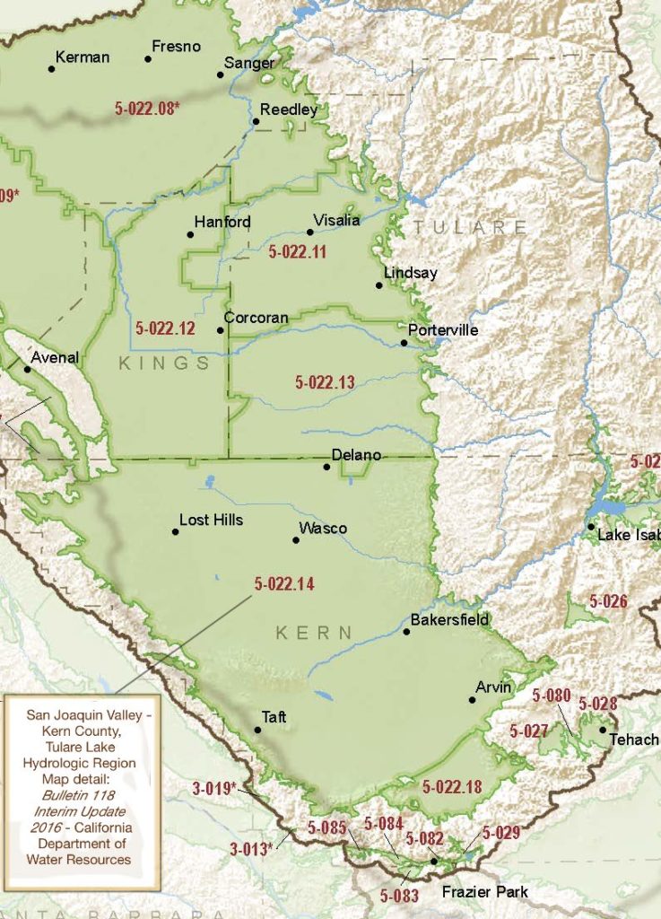
Located in California’s Tulare Lake hydrologic region, the San Joaquin Valley – Kern County subbasin is 1,782,320.81 acres in size. This High priority basin is home to an estimated 699,730 people (2010 value). It has approximately 6174 wells, of which approximately 437 are water supply wells. Groundwater accounts for approximately 80 percent of the basin’s water supply.

Basin Notes
2003: Bulletin 118 basin description
2014: CASGEM basin prioritization – high. Comment: Subsidence, overdraft, water quality degradation. Agricultural importance, large basin, low population density
2016: Basin boundary modifications, approved for Pleasant Valley 5-022.10 and Tule 5-022.13 subbasins, with a Kern 5-022.14 subdivision denied
A new subbasin, White Wolf 5-022.18, was created from a portion of the original Kern County subbasin. The White Wolf subbasin is not subject to critical conditions of overdraft
Revised basin boundary description
2018: Basin draft priority – high. Groundwater level and subsidence comments:
- CRITICAL OVERDRAFT 1) CASGEM/WDL/GWIDS: Longterm hydrographs show groundwater level decline. Source: DWR 2) In some areas of critical overdraft, such as in Kings and Kern counties, complete disconnection between groundwater and overlying surface water systems has occurred. Source: U.S. Bureau of Reclamation
- Sources: 1) Current Land Subsidence in the San Joaquin Valley, USGS; 2) 2014 – Land Subsidence from Groundwater Use in California, California Water Foundation / James W. Borchers / Michael Carpenter, Luhdorff & Salmanini, April 2014; 3) Progress Report: Subsidence in the Central Valley, California, Jet Propulsion Laboratory, California Institute of Technology, NASA 2015-16
Kern Water Bank in the press – Mother Jones, Bay Area News Group, Bakersfield.com, The California Sunday Magazine
2019: Basin boundary modification “approve with deny portion.” Per DWR: “The initial basin boundary modification proposed to revise the western external boundary of the Kern County subbasin to remove portions of older sedimentary rock units, areas of thin alluvium, and included a small portion of external boundary that followed a jurisdictional boundary. The initial scientific information contained deviations from the proposed older and younger alluvial contacts along several portions of the proposed modification. The initial request lacked adequate scientific evidence to demonstrate proposed modification and areas subject to removal did not represent basin or aquifer. One public comment was received on the initial DWR draft decision that supported the agency’s original request. West Kern WD provided a technical study to support and clarify the original request to remove four areas; significant oil producing areas (mapped as QP with Anticlines, older alluvial unit (QP), older rock unit, and subdividing a portion of the basin to create a new subbasin (Little Santa Maria Valley). Some of the additional technical information relied on generalized assumptions regarding the hydrogeologic connectivity between the primary aquifers of the basin and the oil producing areas; without a more detailed analysis, the request to remove these areas are not approved. Also, the request to subdivide the basin and create a new subbasin is not supported by the submitted technical information and is not approved. The removal of the older rock unit and the older alluvial unit (with one exception near Little Santa Maria Valley) is supported and meets the regulatory requirements.” Phase 2 draft priority: high
2020: January 30 –
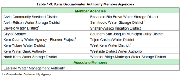
- Kern River Groundwater Sustainability Agency (KRGSA) filed Groundwater Sustainability Plan (GSP) with DWR
- Kern Groundwater Authority (KGA) filed GSP with DWR

Source: KGA GSP 1/30/2020 - Henry Miller Water District filed GSP with DWR (per SGMA portal) but no public copies are available online
Olcese Water District GSA Groundwater Sustainability Plan filed with DWR
2021: December 9 – DWR writes to the 11 GSAs that produced 5 GSPs covering the basin: “Department staff have substantially completed a review of the five GSPs covering the Subbasin and the materials considered to be part of the coordination agreement. While this letter is not a final determination, Department staff have identified several deficiencies which will preclude the Department’s approval of your Plan. The final determination and assessment will be provided to you and posted to the SGMA Portal no later than January 30, 2022. The assessment will describe the deficiencies precluding approval and determine that the Plan is incomplete. The deficiencies described in the forthcoming official written assessment will have accompanying corrective actions that the GSAs must address within 180 days from issuance.”
2022: January 28 – DWR notifies GSAs that the basin-wide plan is incomplete, citing failure to establish consistent standards for undesirable results, criteria for managing groundwater decline and subsidence did not meet SGMA requirements.
April 21 – The Arvin-Edison Water Storage District Groundwater Sustainability Agency (AEWSD GSA), Wheeler-Ridge Maricopa Water Storage District (WRMWSD) GSA, and Tejon-Castac Water District (TCWD) GSA (collectively referred to as the “South Kern GSAs”) notify DWR that, in coordination with the Arvin Community Service District, they intend to initiate development of a Groundwater Sustainability Plan (GSP) for the portion of the Kern County Subbasin (DWR No. 5-022.14) that is South of the Kern River.
July 27 – Henry Miller Water District submits a revised GSP to DWR
Kern County Groundwater Authority resubmits GSP to DWR
July 29 – Kern River GSA resubmits a revised GSP to DWR
August 1 — Buena Vista GSP submitted a new GSP
2023: March 2- DWR finds the revised basin GSPs inadequate
