San Joaquin Valley – Tracy
Statistics
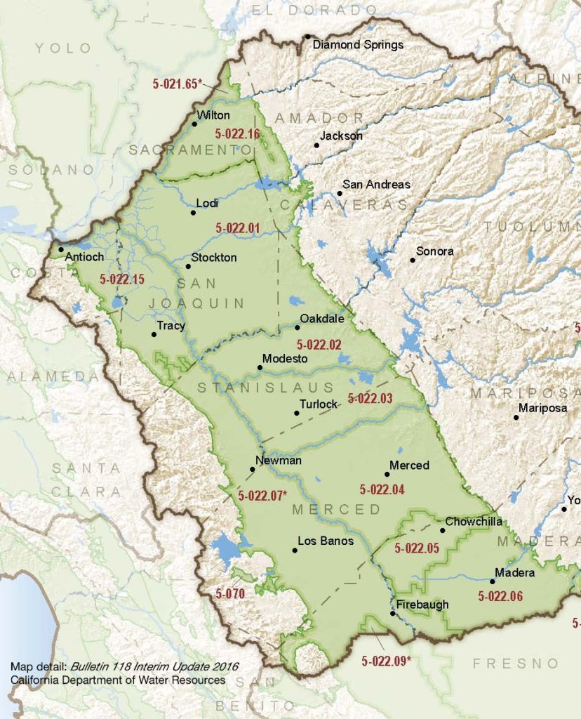
- Basin Name
- San Joaquin Valley – Tracy
- Basin Number
- 5-022.15
- SGMA Basin Priority
- Medium
- Critically Overdrafted
- No
- Hydrologic Region Name
- San Joaquin River
- Counties
- Alameda, Contra Costa, San Joaquin
Basin Notes
2003: Bulletin 118 basin description
2014: CASGEM basin prioritization – medium. Comment: Poor water quality throughout the subbasin (B‐118)
2016: Basin boundary modification requests – one to subdivide the Contra Costa portion of the Tracy subbasin that was denied, while a suite of changes to the boundaries with the Kings 5-022.08, Madera 5-022.06, Westside 5-022.09, Delta-Mendota 5-022.07 subbasins were approved
2018: Draft basin priority – medium. Declining groundwater level and salt intrusion comments:
- 1) CASGEM/WDL/GWIDS: Stable hydrographs. Source: DWR 2) Review of hydrographs from wells throughout the sub-basin indicates that, except for seasonal variation resulting from recharge and pumping, water levels in most of these wells have remained stable over at least the last 10 years. Source: City of Tracy, Tracy Hills Specific Plan SB610/SB221 Water Supply Assessment Final Report, West Yost Associates, 12/2014
- 1) City of Antioch: In April 2003, a source water assessment was conducted for the Antioch Municipal Reservoir and the San Joaquin River source of the City of Antioch water system. The San Joaquin River source was found to be most vulnerable to the effects of saltwater intrusion, chemical/petroleum processing or storage, and regulated point discharges. Water from the San Joaquin River is not always acceptable due to saltwater intrusion. Historically, as major diversions began and the freshwater flows into the Delta decreased, saline bay waters have moved further upstream, replacing the fresh water. When chloride levels in the river exceed 250 milligrams per liter, the City stops pumping until chloride levels decrease. – City of Antioch Annual Water Quality Report 2) The Emergency Drought Barrier was installed from early May through mid-November in 2015. It was constructed in West False River to protect the interior of the Sacramento-San Joaquin Delta from saltwater intrusion during prolonged and exceptional drought conditions. – 2015 Emergency Drought Barrier Water Quality Monitoring Report, DWR, January 2017
2019: Basin boundary modification. Per DWR: It “subdivides the Tracy subbasin along the Contra Costa County line. Multiple outreach meetings were held throughout the basin, and letters were delivered to water systems and local agencies. The requesting agency obtained the required three-quarters support from local agencies and public water systems for a jurisdictional subdivision.”
Phase 2 draft priority: Medium.
2022: January 28 – GSP submitted to DWR
2024: January 18 – GSP approved by DWR
At-A-Glance
California Water Library Documents About This Basin
Decadal Shifts in Groundwater Age Detected by Environmental Tracers Across California
American Geophysical Union (AGU) | March 23rd, 2026
Groundwater age tells us how long water has been underground since it last infiltrated the land surface. Monitoring changes in groundwater age helps identify aquifer stre
San Joaquin Valley Conveyance Study
California Department of Water Resources (DWR) | November 24th, 2025
This San Joaquin Valley Conveyance Study analyzes water conveyance needs in the San Joaquin Valley (Figure ES-1). The purpose of this study is to: •Describe the impa
Replenishing Groundwater in the San Joaquin Valley: 2024 Update
Public Policy Institute of California (PPIC) | June 6th, 2024
Strategies to replenish groundwater basins—long used in some areas of the San Joaquin Valley—have increasingly come into focus as the region seeks to bring its overd
Statement of Findings regarding the Approval of the San Joaquin Valley - Tracy Subbasin Groundwater Sustainability Plan
California Department of Water Resources (DWR) | January 18th, 2024
The Department of Water Resources (Department) is required to evaluate whether a submitted groundwater sustainability plan (GSP or Plan) conforms to specific requirements
Comparing Domestic and Public-Supply Groundwater Quality in the Northern San Joaquin Valley, 2019: California GAMA Priority Basin Project
U.S. Geological Survey (USGS) | June 5th, 2023
Analysis of construction data for wells included in the comparative assessment indicated that, although depth to top of perforations are comparable for domestic and publi
Comparing domestic and public-supply groundwater quality in the northern San Joaquin Valley, 2019—California GAMA Priority Basin Project
U.S. Geological Survey (USGS) | June 5th, 2023
Groundwater quality in the Northern San Joaquin Valley region of California was studied as part of California State Water Resources Control Board (SWRCB) Groundwater Ambi
Modeling the dynamic penetration depth of post-1950s water in unconfined aquifers using environmental tracers: Central Valley, California
Journal of Hydrology (Elsevier) | December 5th, 2022
The penetration depth of post-1950s recharge (D-1950) in aquifers is a marker that is frequently used to identify groundwater that is susceptible to anthropogenic contami
Tracy Subbasin Groundwater Sustainability Plan
County of San Joaquin GSA | November 1st, 2021
The Tracy Subbasin boundaries follow the Old River on the northwest, the Coastal Range on the southwest and south, and the San Joaquin River on the east. The southeast bo
Drought impacts to water footprints and virtual water transfers of the Central Valley of California
American Geophysical Union (AGU) | June 23rd, 2017