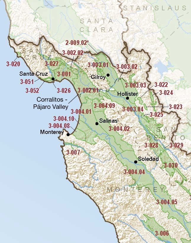
Corralitos – Pájaro Valley
Statistics
- Basin Name
- Corralitos – Pájaro Valley
- Basin Number
- 3-002.01
- SGMA Basin Priority
- High
- Critically Overdrafted
- Yes
- Hydrologic Region Name
- Central Coast
- Counties
- Monterey, Santa Cruz
At-A-Glance
Located in California’s Central Coast hydrologic region, the Corralitos – Pájaro Valley is 75,055 acres in size. This High priority basin is home to an estimated 90,289 people (2010 value). It has approximately 2027 wells, of which approximately 89 are water supply wells. Groundwater accounts for approximately 99.71 percent of the basin’s water supply.

Basin Notes
1984: Pajaro Valley Water Management Agency formed to develop best management practices
2002: Basin Best Management Plan published
2003: Bulletin 118 basin description
2014: February – Basin BMP update published
2016: Major Basin boundary modification approved Bulletin 118 update – Various portions of the original Pajaro Valley Basin were moved to three adjacent subbasins/basins—180/400 Foot Aquifer subbasin (3-004.01), Langley Area Subbasin (3-004.09), and the newly-formed Santa Cruz Mid-County (3-001) basin. A portion of the former Santa Cruz Purisima Formation basin (3-021) was added to this basin. The Pajaro Valley Basin was also reclassified as a subbasin. Revised Basin boundary description
December 31 – Existing Alternative to GSP plan submitted to DWR.
2018: Draft Basin Prioritization comments –
- Groundwater levels and salt intrusion: CRITICAL OVERDRAFT 2016 Source: DWR 1) CASGEM/WDL/GWIDS: No data or data insufficent to determine GWL status. Source: DWR 2) Seawater intrusion in the Pajaro Basin, a result of groundwater overdraft, was first ocumented in 1953 (Bulletin 5, SWRCB). Since then, the problem has become more severe. The Pajaro Valley groundwater basin is in severe overdraft, causing groundwater elevations to drop below sea level as shown in Figure ES-1 and leading to seawater intrusion. Seawater intrusion has caused chloride contamination of groundwater wells up to three miles inland, as shown in Figure ES-2. Source: Pajaro Valley Water Management Agency Basin Management Plan Update
The current seawater intrusion rate in the Pajaro Valley is estimated to be 100 to 250 feet per year, and its effects already extend several miles inland (PVWMA, 2014A). …In April 2014, the Pajaro Valley Water Management Agency Board of Directors adopted a Basin Management Plan update. The plan proposes six projects and an aggressive conservation program that will reduce groundwater over pumping by 90% and essentially halt seawater intrusion into the Pajaro Valley Aquifer (PVWMA, 2014B). Source: CentralCoastGWReport-Aug2014.pdf 2) Today, the need to abate groundwater overdraft and prevent further seawater intrusion into the coastal aquifer drives the PVWMAs conjunctive use and groundwater management program. Beginning in the early 1990s, the PVWMA started establishing a water supply system that today combines surface, groundwater, and recycled water to sustain valley farms and work to recharge declining groundwater aquifers. The Agency still has much to do, and in its ongoing basin management planning efforts, is working alongside university researchers, as well as with local stakeholder groups to develop the most cost-effective and efficient programs and projects. Source: PajaroValleyGWM.pdf 2018 Final Basin Prioritization: Basin status remains unchanged at high priority.
2019: July 17 – Alternative approved by DWR
2021: November 17 – Pajaro Valley Basin Management Plan Groundwater Sustainability Update
2023: December 29 – Strawberry Case Study: What If Farmers Had to Pay for Water? , New York Times

