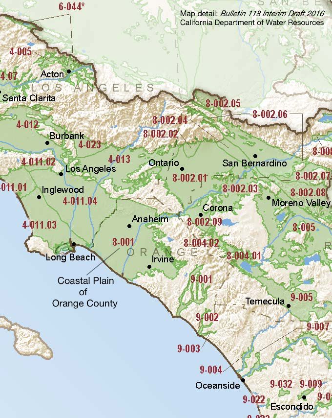
Coastal Plain of Orange County
Statistics
- Basin Name
- Coastal Plain of Orange County
- Basin Number
- 8-001
- SGMA Basin Priority
- Medium
- Critically Overdrafted
- No
- Hydrologic Region Name
- South Coast
- Counties
- Orange
- Adjacent Basins
At-A-Glance
Located in California’s South Coast hydrologic region, the Coastal Plain of Orange County is 224,226 acres in size. This Medium priority basin is home to an estimated 2,308,162 people (2010 value). It has approximately 437 wells, of which approximately 222 are water supply wells. Groundwater accounts for approximately 72.87 percent of the basin’s water supply.

Basin Notes
2003: Bulletin 118 basin description
2014: CASGEM basin prioritization – medium. Comment – saline intrusion issues.
2016: Basin boundary modification with La Habra deemed incomplete; border modification with Coastal Plain of Los Angeles approved
Revised basin boundary description
Analysis of basin conditions for an alternative to GSP
2017: Orange County Water District alternative GSP proposal (approved) and SGMA portal
2018: Draft prioritization – Comments
- Groundwater level: 1) Longterm hydrographs show groundwater level decline. Source: DWR 2) GWMP Update 2015, some hydrographs show declining GWLs. Source: Orange County Water District Groundwater Management 2015 Update
- Salt intrusion: 1) In the Coastal Plain of Orange County Groundwater Basin, the groundwater is characterized as sodium-calcium bicarbonate with localized areas of high TDS due to sea water intrusion along the Pacific Ocean coast, as well as nitrate, and volatile organic compounds (DWR 2004. Groundwater is recharged naturally from precipitation and injection wells to reduce seawater intrusion. The Orange County Water District also injects water into the Talbert Barrier and the portion of the Alamitos Barrier Project within Orange County. Water supplies for the seawater barriers include water from the Groundwater Replenishment System and SWP water (GWRS n.d.; MWDSC 2007). Source: Coordinated Long-Term Operation of the Central Valley Project and State Water Project EIS, Chapter 7, US Bureau of Reclamation
- Subsidence: 1) “There is little potential for future widespread permanent, irreversible subsidence given OCWDs statutory commitment to sustainable groundwater management and policy of maintaining groundwater storage levels within a specified operating range. Nevertheless, the District annually reviews Surveyor data to evaluate ground surface fluctuations within the Districts service area. If irreversible subsidence was found to occur in a localized area in relation to groundwater pumping patterns or groundwater storage conditions, OCWD would coordinate with local officials to investigate and develop an approach to address the subsidence.” OCWD also avoids exceeding the safe yield to reduce the chances of inelastic subsidence. Real time monitoring network “consists of continuously operating GPS reference stations that monitor horizontal and vertical movement throughout Orange County.” “GPS data collected by the Surveyor over the past 12 years (2002-2014) show that the ground surface fluctuations appear to be completely elastic, reversible, and well correlated with fluctuations in groundwater levels. The “data indicate that there has NOT been any permanent, irreversible subsidenc of the ground surface over the past 12 years.” Subsidence began as early as 1898; groundwater storage conditions were at historical lows in the late 1950s. “More recent data show a consistent pattern of the ground surface rising and falling in tandem with groundwater levels and overall changes in basin groundwater storage.” Source: Orange County Water District Groundwater Management Plan 2015 Update
2018 Final basin prioritization: Medium.
