Death Valley
Statistics
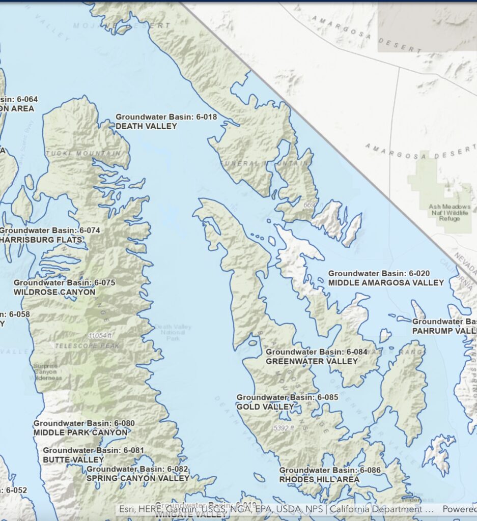
- Basin Name
- Death Valley
- Basin Number
- 6-018
- SGMA Basin Priority
- Very Low
- Critically Overdrafted
- Hydrologic Region Name
- South Lahontan
- Counties
- Inyo, San Bernardino
- Adjacent Basins
-
Middle Amargosa Valley 6-020, Marble Canyon Area 6-064, Greenwater Valley 6-084, Wingate Valley 6-019, Lower Kingston Valley 6-021, Rhodes Hill Area 6-086, Leach Valley 6-027, Race Track Valley 6-062, Denning Spring Valley 6-078, ,
Basin Notes
At-A-Glance
California Water Library Documents About This Basin
Hydroclimate response of spring ecosystems to a two‐stage Younger Dryas event in western North America
Nature Portfolio (Springer Nature) | May 5th, 2022
The Younger Dryas (YD) climate event is the preeminent example of abrupt climate change in the recent geologic past. Climate conditions during the YD were spatially compl
Groundwater Characterization and Effects of Pumping in the Death Valley Regional Groundwater Flow System, Nevada and California, with Special Reference to Devils Hole
U.S. Geological Survey (USGS) | March 5th, 2020
Groundwater flow and development were characterized in four groundwater basins of the Death Valley regional flow system in Nevada and California with calibrated, groundwa
Evaluating Micrometeorological Estimates of Groundwater Discharge from Great Basin Desert Playas
National Groundwater Association (NGWA) | March 6th, 2018
Groundwater availability studies in the arid southwestern United States traditionally have assumed that groundwater discharge by evapotranspiration (ETg) from desert play
Data Measured on Water Collected from Eastern Mojave Desert, California
U.S. Department of Energy (DOE) | August 18th, 2017
In March of 2000 field collection of water from the Eastern Mojave Desert resulted in the measurement of stable isotope, radiocarbon, tritium, and limited dissolved nobl
Testing the Established Hydrogeologic Model of Source Water to the Amargosa River Basin, Inyo and San Bernardino Counties, California
Environmental Forensics (Taylor & Francis) | November 15th, 2015
The current conceptual hydrogeologic model established for source water to the Amargosa River was tested in order to help inform management decisions regarding the Amargo
California Water Plan Update 2013: South Lahontan Hydrologic Region Report
California Department of Water Resources (DWR) | October 30th, 2014
Several of California’s well-known natural resources are located in the South Lahontan Hydrologic Region. They include Mono Lake, Death Valley, the Owens Valley, and th
Three-dimensional geologic mapping of the Cenozoic basin fill, Amargosa Desert basin, Nevada and California
U.S. Geological Survey (USGS) | July 1st, 2014
Understanding the subsurface geologic framework of the Cenozoic basin fill that underlies the Amargosa Desert in southern Nevada and southeastern California has been impr
Groundwater Geology and Hydrology of Death Valley National Park, California and Nevada
U.S. Department of the Interior (DOI) | December 3rd, 2012
Conceptual Model of the Great Basin Carbonate and Alluvial Aquifer System
U.S. Geological Survey (USGS) | September 20th, 2011
Death Valley regional groundwater flow system, Nevada and California—Hydrogeologic framework and transient ground-water flow model
U.S. Geological Survey (USGS) | August 23rd, 2010
Death Valley regional ground-water flow system, Nevada and California—Hydrogeologic framework and transient ground-water flow model
U.S. Geological Survey (USGS) | July 1st, 2010
A numerical three-dimensional (3D) transient groundwater flow model of the Death Valley region was developed by the U.S. Geological Survey for the U.S. Department of Ener
Focused groundwater recharge in the Amargosa Desert basin
U.S. Geological Survey (USGS) | July 1st, 2007
The Amargosa River is an approximately 300-kilometer-long regional drainage connecting the northern highlands on the Nevada Test Site in Nye County, Nev., to the floor
A Guide for Using the Transient Ground-Water Flow Model of the Death Valley Regional Ground-Water Flow System, Nevada and California
U.S. Geological Survey (USGS) | November 4th, 2006
This report is a guide for executing numerical simulations with the transient ground-water flow model of the Death Valley regional ground-water flow system, Nevada and Ca
Annual Ground-Water Discharge by Evapotranspiration from Areas of Spring-Fed Riparian Vegetation Along the Eastern Margin of Death Valley, 2000–02
U.S. Geological Survey (USGS) | July 1st, 2006
Death Valley lower carbonate aquifer monitoring program—Wells down gradient of the proposed Yucca Mountain nuclear waste repository: U.S. Department of Energy Cooperative Agreement DE-FCO8-02RW12162 Final Project Report
Inyo County | July 1st, 2005
Hydrologic Components for Model Development, Chapter C of Death Valley Regional Ground-Water Flow System, Nevada and California—Hydrogeologic Framework and Transient Ground-Water Flow Model
U.S. Geological Survey (USGS) | July 1st, 2004
Estimated ground-water discharge by evapotranspiration from Death Valley, California
U.S. Geological Survey (USGS) | July 1st, 2003
Estimated Ground-Water Withdrawals from the Death Valley Regional Flow System
U.S. Geological Survey (USGS) | July 1st, 2003
Detection and Measurement of Land Subsidence Using Interferometric Synthetic Aperture Radar and Global Positioning System, San Bernardino County, Mojave Desert, California
U.S. Geological Survey (USGS) | July 1st, 2003
A three-dimensional numerical model of predevelopment conditions in the Death Valley regional ground-water flow system, Nevada and California
U.S. Geological Survey (USGS) | July 1st, 2002