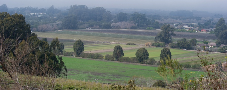
Groundwater is intimately connected with the landscape and land use that it underlies. The way the land is used – the type of use and the level of use – has a direct relationship to water supplies and water quality issues.
Land use decisions that fail to consider groundwater can contribute to loss of groundwater recharge, increasing water demand, and groundwater contamination. However, land use practices that protect and conserve groundwater (and surface water) resources and maintain recharge areas are key to maintaining long-term water availability and economic vitality.
State government has a limited role in land use planning; most of this authority rests with local governments. State law does require that state policies with respect to land use be expressed through local general plans and land use regulations.
Developing a strong collaboration between land use planners and water managers can promote more efficient land use patterns and regional water management practices.
Key information:
Smart Water, Smart Planning: Managing California’s Groundwater
From the Local Government Commission:
Safe, clean water is essential to California, its nearly 39 million residents, its vibrant and diverse economy, and its cherished quality of life. However, the supply of accessible, affordable clean water in adequate and sustainable amounts to meet California’s needs is limited and relatively finite.
It is becoming increasingly evident to policymakers that to accommodate the often-competing needs of various end-users, while providing for continued demographic and economic growth, requires careful, forward-thinking management of California’s water resources.
To read more from the Local Government Commission, click here.
Growing Water Smart: The Water-Land Use Nexus
 By 2050, California’s population is predicted to grow to 50 million, putting pressure on our state’s already limited water resources. A growing population can escalate the costs of operating local utilities, the need for enhanced and expanded infrastructure, and, if the water supply is constrained, the cost of acquiring new sources. In the past, water resource managers and water providers have turned to supply side management to meet growing demand by investing in water acquisition, treatment, and storage and distribution projects. However, these options come with a significant price tag and can be more resource intensive.
One of the more promising strategies in water demand management is integrating land use planning with water conservation and efficiency. Communities throughout the West have found that by increasing development density, utilizing technological efficiencies, and aggressive conservation programs, they have been able to continue to grow without acquiring new supplies.
Click here for this report from the Local Government Commission.
[/su_spoiler]Groundwater sustainability in the San Joaquin Valley: Multiple benefits if agricultural lands are retired and restored strategically
From California Agriculture:
 Sustaining the remarkable scale of agriculture in the San Joaquin Valley has required large imports of surface water and an average annual groundwater overdraft of 2 million acre-feet (Hanak et al. 2017). This level of water demand is unsustainable and is now forcing changes that will have profound social and economic consequences for San Joaquin Valley farmers and communities. Land will have to come out of agricultural production in some areas.
Yet, the emerging changes also provide an important opportunity to strike a new balance between a vibrant agricultural economy and maintenance of natural ecosystems that provide a host of public benefits — if the land is retired and restored strategically.
Groundwater & Land Use Planning & Development
From the Groundwater Protection Council:
 Ensuring enough quality water to support various land uses and economic development can be the driving force toward increased groundwater protection efforts at the local level. As uses change from rural to urban or agricultural to suburban lifestyles, we must pay careful attention to how we modify the natural environment. Land-use decisions that fail to consider the long-term quality, availability and susceptibility of groundwater resources create conditions that contribute to loss of groundwater recharge, overuse of water resources, and human health and ecological impacts resulting from groundwater contamination. On the other hand, land-use practices that protect and conserve water resources and maintain or even increase aquifer recharge are key to maintaining long-term water availability and economic vitality.
Land-use planning and development decisions must routinely take into account such factors as the location, quality, yield, vulnerability, and recharge potential of aquifers and the projected availability of water for the long term. To be truly effective, this information must be incorporated into local comprehensive plans and policies. Fortunately, there is a growing body of land-use tools that provide effective ways to protect groundwater and the environment as a whole and to maintain and improve our quality of life. But it is essential that local decisionmakers have access to these tools and that they apply them to land-use planning, zoning, and land-acquisition decisions. When they do this, they can effectively protect and sustain their local groundwater resources.
Protection of Groundwater Recharge Areas
Recharge areas are those areas that provide the primary means of replenishing groundwater. Good natural recharge areas are those where good quality surface water is able to percolate through the sediments and rocks to the saturated zone which contains groundwater. If recharge areas cease to function properly, it will limit groundwater replenishment and/or groundwater quality for storage or use.
Protection of recharge areas requires a number of actions based on two primary goals: (1) ensuring that areas suitable for recharge continue to be capable of adequate recharge rather than being covered by urban infrastructure, such as buildings and roads, and (2) preventing pollutants from entering groundwater to avoid expensive treatment that may be necessary prior to beneficial use.
Tool: DWR’s Land Use Viewer
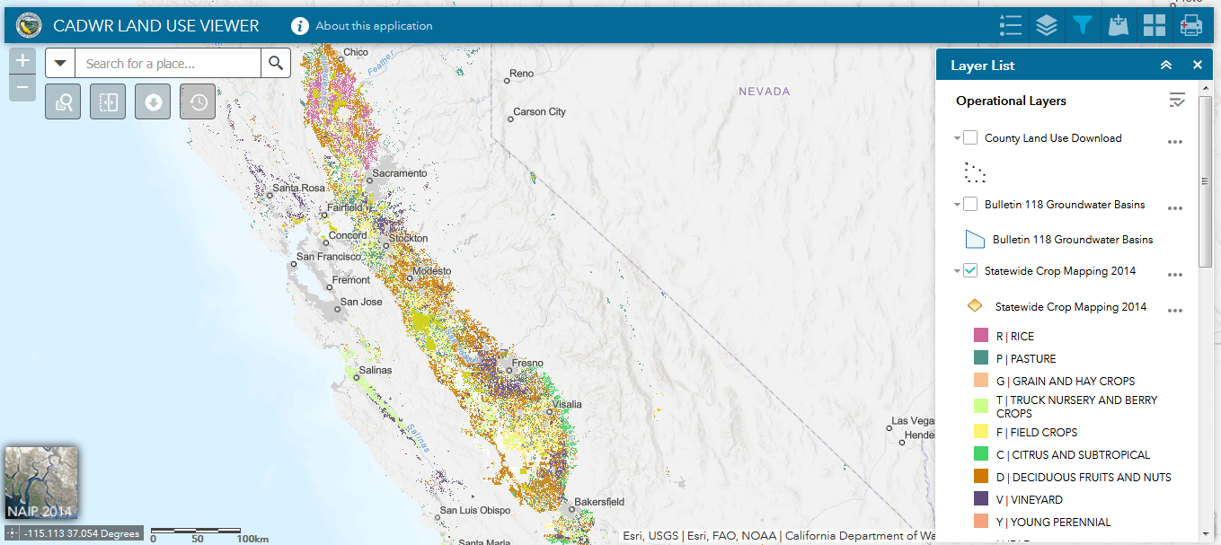 DWR’s Land Use Viewer allows GSAs and the public to easily access both statewide (as recent as 2014 crop data) and existing county land use datasets that have been collected over the last 30 years. The Viewer also includes a variety of tools that will allow users to download and analyze land use data.
Tool: Well completion data
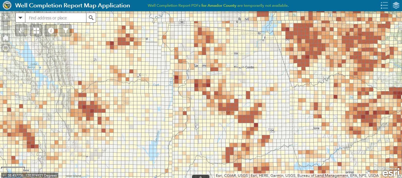 This DWR mapping tool provides direct statewide access to copies of Well Completion Reports, which contain information on planned use, depth of the well, subsurface geologic units encountered, well construction, and well yield.