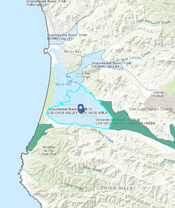
Los Osos Valley – Los Osos Area
Statistics
- Basin Name
- Los Osos Valley – Los Osos Area
- Basin Number
- 3-008.01
- SGMA Basin Priority
- Very Low
- Critically Overdrafted
- No
- Hydrologic Region Name
- Central Coast
- Counties
- San Luis Obispo
- Adjacent Basins
-
Los Osos Valley - Warden Creek 3-008.02,
Basin Notes
2019: Created in by subdivision of Los Osos Valley 3-008. Priority went from critical overdraft to very low by dint of basin boundary modification and excision of adjudicated areas. For plans to do with gestating GSA required under former critical overdraft status, contact SLO County, contact below.
At-A-Glance
California Water Library Documents About This Basin
Los Osos Valley Groundwater Basin Fringe Areas Characterization
San Luis Obispo County Flood Control and Water Conservation District | May 22nd, 2018
The Sustainable Groundwater Management Act (SGMA) took effect on January 1, 2015, and requires that certain actions be taken in groundwater basins designated as either hi
Los Osos Community Services District v. Golden State Water Company
Superior Court of California, County of San Luis Obispo | October 14th, 2015
This Stipulated Judgment concerns the Los Osos Groundwater Basin, as it is more particularly described in Sections 1.4.2 and 2.1 of this Stipulated Judgment, which underl
Hydrogeology and Water Resources of the Los Osos Valley Ground-Water Basin, San Luis Obispo County, California
U.S. Geological Survey (USGS) | July 18th, 1988
The Los Osos Valley ground-water basin is located on the coast of central California. It extends about 3 miles inland and an unknown distance offshore, where it is in h
Water Supply Conditions in Southern California during 1958-1959, Volume II, Water Level Data, Central Coastal and Los Angeles Regions
California Department of Water Resources (DWR) | May 1st, 1961
Bulletin No. 39-58, Water Supply Conditions in Southern California during 1957-1958, Volume II, Precipitation and Water Level Data, Central Coastal and Los Angeles Regions
California Department of Water Resources (DWR) | August 1st, 1960
Bulletin No. 39-57, Water Supply Conditions in Southern California during 1956-1957, Volume II, Precipitation and Water Level Data Central Coastal and Los Angeles Regions
California Department of Water Resources (DWR) | June 16th, 1958
Bulletin No. 39-57 Volume I Bulletin No. 39-57 Volume III Bulletin No. 39-57 Volume IV